Back away from the beans and cabbage, right NOW!All your Global Warming are belong to me.
It’s all me. I did it. And I’ll do it again tomorrow.
Join the Hide community
Get access to live stream, lessons, the post exchange, and chat with other snipers.
Register
Download Gravity Ballistics
Get help to accurately calculate and scope your sniper rifle using real shooting data.

Install the app
How to install the app on iOS
Follow along with the video below to see how to install our site as a web app on your home screen.
Note: This feature may not be available in some browsers.
You are using an out of date browser. It may not display this or other websites correctly.
You should upgrade or use an alternative browser.
You should upgrade or use an alternative browser.
Maggie’s Funny & awesome pics, vids and memes thread (work safe, no nudity)
- Thread starter Lawless
- Start date

Um, excuse me. Hi, exhausted Gen Xer here. Does this mean you caused the global warming or you took it away? If you’re taking it away, how much do you want to keep cooling everything off a few more degrees? And if you’re causing it, eat shit and dieAll your Global Warming are belong to me.
It’s all me. I did it. And I’ll do it again tomorrow.
We all caused the global warming, and we’re damn proud of it!
Where is that drum of benzene I got a pour into the river behind my house?
Where is that drum of benzene I got a pour into the river behind my house?
Um, excuse me. Hi, exhausted Gen Xer here. Does this mean you caused the global warming or you took it away? If you’re taking it away, how much do you want to keep cooling everything off a few more degrees? And if you’re causing it, eat shit and die
Yes.
probably sitting next to the barrel of PCBs (Polychlorinated biphenyls) .We all caused the global warming, and we’re damn proud of it!
Where is that drum of benzene I got a pour into the river behind my house?


Holy heck!!! Made it!!! With one small detour of about 2500 miles, followed Lewis and Clark from Council bluffs to their winter camp. Some of the route was actually Clark’s return route and Colters return through Yellowstone.
But for long stretches of the Missouri and then from East of Three Forks to the Fort ( across the bitterroot’s) was basically right on the trail.
Only ran about 300 miles of Interstate the whole trip! All back roads and state roads.
Some sections (like LOLO) I covered in a day what it took them a month to cover. Impossible to appreciate how tough those guys were. Absolutely impossible.

Sirhr
But for long stretches of the Missouri and then from East of Three Forks to the Fort ( across the bitterroot’s) was basically right on the trail.
Only ran about 300 miles of Interstate the whole trip! All back roads and state roads.
Some sections (like LOLO) I covered in a day what it took them a month to cover. Impossible to appreciate how tough those guys were. Absolutely impossible.
Sirhr
Last edited:
Fort Clatsop.
And one of Mount Hood, which Lewis used to confirm they were in the right place. (The Columbia River had been explored from the West in the 1700’s).


Incredible figure/fact. If you take the Lewis and Clark map, which was done entirely by pacing and compass readings it is off by only about 40 miles over some 4000 miles traveled. It is an absolutely unbelievable feat of land navigation. Even more so considering the primitive equipment they had at the time. Compass, Sextant, pacing. And hand drawn paper maps. The accuracy of their trip record is uncanny.

And one of Mount Hood, which Lewis used to confirm they were in the right place. (The Columbia River had been explored from the West in the 1700’s).
Incredible figure/fact. If you take the Lewis and Clark map, which was done entirely by pacing and compass readings it is off by only about 40 miles over some 4000 miles traveled. It is an absolutely unbelievable feat of land navigation. Even more so considering the primitive equipment they had at the time. Compass, Sextant, pacing. And hand drawn paper maps. The accuracy of their trip record is uncanny.
Last edited:
Is that the Girardoni air rifle I see in the case in the background?Fort Clatsop.
And one of Mount Hood, which Lewis used to confirm they were in the right place. (The Columbia River had been explored from the West in the 1700’s).
View attachment 8772949
View attachment 8772951
View attachment 8772952
View attachment 8772953
Incredible figure/fact. If you take the Lewis and Clark map, which was done entirely by pacing and compass readings it is off by only about 40 miles over some 4000 miles traveled. It is an absolutely unbelievable feet of land navigation. Even more so considering the primitive equipment they had at the time. Compass, Sextant, pacing. And hand drawn paper maps. The accuracy of their trip record is uncanny.
View attachment 8772954
One of them. But I think a replica.
All their gear was basically sold at some trading post in St Louis when they got back to “civilization” and I don’t think much survives
One of the cool things was their “ball tubes” that are brass dispensers for musket balls. With little hinged lids. I have to make a couple of those!!!


.50” brass tube with one end soldered shut and a flip cap. Totally cool and never seen one!!
Sirhr
All their gear was basically sold at some trading post in St Louis when they got back to “civilization” and I don’t think much survives
One of the cool things was their “ball tubes” that are brass dispensers for musket balls. With little hinged lids. I have to make a couple of those!!!
.50” brass tube with one end soldered shut and a flip cap. Totally cool and never seen one!!
Sirhr
“Feat”
Just sayin’…. But yeah, pretty remarkable, and a great testament to the level of fundamental knowledge that is no longer taught.
Land and sea navigation using a sextant and the stars only became precise enough to be really useful with the invention of accurate clocks small enough to carry, but the math would still get ya close. Still, that level of precision back then is remarkable.
Mental illness is a privilege
“Feat”
Just sayin’…. But yeah, pretty remarkable, and a great testament to the level of fundamental knowledge that is no longer taught.
Land and sea navigation using a sextant and the stars only became precise enough to be really useful with the invention of accurate clocks small enough to carry, but the math would still get ya close. Still, that level of precision back then is remarkable.
%*+€ing autocorrect!!
Sirhr
“Feat”
Just sayin’…. But yeah, pretty remarkable, and a great testament to the level of fundamental knowledge that is no longer taught.
Land and sea navigation using a sextant and the stars only became precise enough to be really useful with the invention of accurate clocks small enough to carry, but the math would still get ya close. Still, that level of precision back then is remarkable.
I need to look up whether they carried chronometers. The Harrison clocks/chronometers were well established by 1805. But how many chronometers were in American hands?
Could they survive the voyage? Sea voyages are one thing. Banging about in keep boats, canoes and horseback is another! I will look that up!
That said, they could Do something the Mariners couldn’t. They could take sightings to landmarks and pace Off distances. So they may not have needed a chronometer to keep track of Longitude.
But great question and I will do some
Digging on that!!
Sirhr
@sirhrmechanic, "Undaunted Courage" is a book you may find interesting, if you haven't read it already.
Lewis and Clark carried an Arnold-style chronometer, which was a highly accurate timepiece essential for determining longitude during their expedition.
Lewis purchased a gold-cased chronometer, often referred to as "Arnold's Watch," from Philadelphia clockmaker Thomas Parker for $250, the largest single expense for any item on the expedition. It was almost certainly not made by Arnold in London. Pretty sure the US and London were not sharing strategic resources like chronometers that early. And chronometers were considered great military assets at the time.
So when they referred to it as an Arnold‘s watch, it was kind of a generic term. Arnold improved on Harrison and was one of the top makers of the day.

It likely looked similar to this one.
The chronometer was crucial for celestial navigation, allowing the captains to calculate their longitude by comparing local time with the known time at a reference meridian. Although the chronometer lost approximately 14 to 15 seconds per day, it was carefully regulated by Andrew Ellicott in Lancaster, Pennsylvania, and further adjusted by Henry Voigt, a prominent clockmaker in Philadelphia, who also built a protective mahogany case with a suspension system to minimize damage from movement.
Despite its importance, the chronometer was occasionally neglected and allowed to run down, which affected the accuracy of time-based observations. Nonetheless, it remained one of the most critical instruments for their scientific and navigational tasks.
Some of this is AI generated, BTW. I added some details.
Sirhr
Lewis purchased a gold-cased chronometer, often referred to as "Arnold's Watch," from Philadelphia clockmaker Thomas Parker for $250, the largest single expense for any item on the expedition. It was almost certainly not made by Arnold in London. Pretty sure the US and London were not sharing strategic resources like chronometers that early. And chronometers were considered great military assets at the time.
So when they referred to it as an Arnold‘s watch, it was kind of a generic term. Arnold improved on Harrison and was one of the top makers of the day.
It likely looked similar to this one.
The chronometer was crucial for celestial navigation, allowing the captains to calculate their longitude by comparing local time with the known time at a reference meridian. Although the chronometer lost approximately 14 to 15 seconds per day, it was carefully regulated by Andrew Ellicott in Lancaster, Pennsylvania, and further adjusted by Henry Voigt, a prominent clockmaker in Philadelphia, who also built a protective mahogany case with a suspension system to minimize damage from movement.
Despite its importance, the chronometer was occasionally neglected and allowed to run down, which affected the accuracy of time-based observations. Nonetheless, it remained one of the most critical instruments for their scientific and navigational tasks.
Some of this is AI generated, BTW. I added some details.
Sirhr
@sirhrmechanic, "Undaunted Courage" is a book you may find interesting, if you haven't read it already.
I read that before starting!
I read the diaries in high school. But found them to be really tough reading. Ambrose did a brilliant job telling the story. As usual.
The Ken Burns 1997 two-part documentary is brilliant As well. And the cinematography is superlative!
Sirhr


If you play with Japanese motorcycles you need a set of JIS screwdrivers. You might think that your Phillips will work....you are wrong.
If you play with Japanese motorcycles you need a set of JIS screwdrivers. You might think that your Phillips will work....you are wrong.
Last Jap bike I had was a CB360 in 1988. And it never needed anything! ;-)
Sirhr
Mount hood… you can see the crater from the last time it blew!!!

The Pacific!!! Finally!

The Astoria-Washington bridge. That’s some engineering!!!

Sirhr
The Pacific!!! Finally!
The Astoria-Washington bridge. That’s some engineering!!!
Sirhr
Cas
I really like your wood!!!
It's not gay if it's the shooting sports
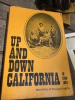
@sirhrmechanic Another good book from slightly later is “Up and Down California” by William H. Brewer.@sirhrmechanic, "Undaunted Courage" is a book you may find interesting, if you haven't read it already.
He was the Botanist on Dr. Whitney’s USGS Survey of California from 1860-1864. Very observant and articulate writer. What was more impressive is that the majority of elevations and locations that they mapped (except in areas of significant seismic activity) were within inches when mapped by satellite in the 1980’s and 90’s.
Attachments
Last edited:
Have you tried the Tabasco Siracha? Much better than the current rooster version.I consume a big bottle every few weeks

Similar threads
- Replies
- 17
- Views
- 949
- Replies
- 13
- Views
- 1K
