Join the Hide community
Get access to live stream, lessons, the post exchange, and chat with other snipers.
Register
Download Gravity Ballistics
Get help to accurately calculate and scope your sniper rifle using real shooting data.

Install the app
How to install the app on iOS
Follow along with the video below to see how to install our site as a web app on your home screen.
Note: This feature may not be available in some browsers.
You are using an out of date browser. It may not display this or other websites correctly.
You should upgrade or use an alternative browser.
You should upgrade or use an alternative browser.
Kestrel, valuable tool or waste of money?
- Thread starter Scorpion King
- Start date
Hi,
Just a quick clarification...
Barometic pressure (more fully it's "mean sea-level barometric pressure") is corrected.
It's what the weather person reads out.
It's near 29.9" Hg, 1013.3 HPa, 14 psi.
They obtain this by measuring the actual pressure is at a place and then calculating what the equivalent pressure would be if this place was at sea level.
It's an estimation.
Station pressure is what the actual air is around you - it's what your pressure sensor should tell you.
It's usually less than the above (unless you're below sea level).
Yes, you don't need altitude - as Lowlight says, you just need to know how dense the air is around you.
So one can:
1) Measure it = use a Kestral (some GPS's have pressure guages as well, because measuring altitude with pressure is more accurate than using satellites) and get a value <= 29.9 (need some common sense here: one can figure out that if you are in Denver and the machine is saying 29.9 then it's corrected. It should be less - say 24.6 (830 HPa) for 5280'/1609m)
2) Calculate = listen to the weather for the (corrected) barometric pressure and then find out what altitude you are (map, GPS, sign). Then you can ESTIMATE the actual pressure where you are (aviators know all about this). This is why many ballistic calculators ask you for altitude - that's what they are doing for you. (Note: there are various models to do this - many depend on temperature gradients in the atmosphere). Many web pages exist to do the same thing. This is the reverse procedure for what the weather people do before reporting it.
So, because people are a bit loose with terminology, it's generally a good idea to forget all about altitude; use station pressure and understand roughly what the pressure should be around you as a sanity check.
One caution: ballistic programs like AE have the ability to pull 'weather data' from the nearest station and apply it to your ballistic solution. This is fraught with danger - esp in mountainous country. Many weather stations are on mountain tops (at least here). That wouldn't be so bad, but these weather stations seem to sometimes supply corrected pressure and sometimes uncorrected (and the program doesn't seem to know which).
I have a Kestrel but I really prefer my mechanical barometer and a small thermometer. I have an older Silva that works great. Silva still makes a mechanical unit. After that, I run DA charts. No batteries. The wind function I find pretty useless. Experience is a better solution for wind.
Silva ADC Ridge Mechanical Altimeter
Silva ADC Ridge Mechanical Altimeter
I have a Kestrel but I really prefer my mechanical barometer and a small thermometer. I have an older Silva that works great. Silva still makes a mechanical unit. After that, I run DA charts. No batteries. The wind function I find pretty useless. Experience is a better solution for wind.
Silva ADC Ridge Mechanical Altimeter
Hmmm. Looks like the non-metric version is badged under Brunton.
Alternatives:
Analog Altimeters
No, barometric pressure is a function of altitude, plus weather.
You can use EITHER one. And if you run the numbers based on the actual pressures at a given location, like I did in the Basic Marksmanship thread on the subject, for the Bang Steel range, from the lowest pressure to the highest pressure from the local weather reporting site, you get a range of 0.1 mil difference at 1000 yards for my .308 load. The pressure over the last 9 months has ranged from (corrected) 29.70" - 30.40". So +0.48 to -0.22 from standard. Not a huge difference.
The point is, you DO NOT NEED actual pressure. If you have it, great, but the pressure doesn't vary that much for a given localtion, except in very unusual weather conditions, like a hurricane.
A 1000 foot difference in DA due to pressure, would be about a 1 inch Hg of pressure difference, which is a LOT.
Your thinking is flawed on several levels. Sure there is more than one way to skin the cat, but now you are relying on an accurate altitude reading when most are using a kestrel which is a pressure reading device not a GPS.
The bullet cares about air density as noted above by several people, this is why Density Altitude works, which really has very little to do with altitude.
it uses pressures & temperature, so why when you can use DA would you steer people away from pressure and their kestrel ? Altitude is much harder to accurately figure. If you stick to the same range all the time you certainly can use corrected values but that is a flawed practice to teach or even consider. People who travel, people with experience shooting in a variety of locations are smart to use station pressure with a kestrel. Saying you can shortcut it doesn't change the fact, you can ALSO shortcut the process by NOT using altitude. Look at Ballistic AE or several other Apps. You can use just Station or Absolute Pressure and a Temperature which turns off the altitude. With a Ballistic Calculator using altitude you still need all the inputs, BP, Temp, Humidity & Altitude. Seems silly to chase altitude when the bullet is worried about pressure.
Station Pressure includes the altitude, so you're cutting out the need to get that data. You can ignore altitude, you can set your humidity to 50% and then just focus on Temperature & Station Pressure. Which also makes your Density Altitude correct in the same meter. You have 3 valid values. You don't set your altitude via a GPS to correct the pressure, which then doesn't screw up you DA reading. You're working in a less efficient manner using corrected pressure and altitude.
In essence you doing it backwards and because you can, you're calling it good. But it invalidates your other valuable asset, Density Altitude. Not good business, we can talk to each other in clicks too, but we don't for a reason. The goal is to increase accuracy, not include a 1 minute fudge factor, which with rounding and errors has the potential to grow.
The bullet cares about air density as noted above by several people, this is why Density Altitude works, which really has very little to do with altitude.
Density altitude is the altitude relative to the standard atmosphere conditions (International Standard Atmosphere) at which the air density would be equal to the indicated air density at the place of observation, or, in other words, the height when measured in terms of the density of the air rather than the distance from the ground. "Density Altitude" is the pressure altitude adjusted for non-standard temperature
Both an increase in temperature, pressure, and, to a much lesser degree, humidity will cause an increase in density altitude. Thus, in hot and humid conditions, the density altitude at a particular location may be significantly higher than the true altitude.
it uses pressures & temperature, so why when you can use DA would you steer people away from pressure and their kestrel ? Altitude is much harder to accurately figure. If you stick to the same range all the time you certainly can use corrected values but that is a flawed practice to teach or even consider. People who travel, people with experience shooting in a variety of locations are smart to use station pressure with a kestrel. Saying you can shortcut it doesn't change the fact, you can ALSO shortcut the process by NOT using altitude. Look at Ballistic AE or several other Apps. You can use just Station or Absolute Pressure and a Temperature which turns off the altitude. With a Ballistic Calculator using altitude you still need all the inputs, BP, Temp, Humidity & Altitude. Seems silly to chase altitude when the bullet is worried about pressure.
Station Pressure includes the altitude, so you're cutting out the need to get that data. You can ignore altitude, you can set your humidity to 50% and then just focus on Temperature & Station Pressure. Which also makes your Density Altitude correct in the same meter. You have 3 valid values. You don't set your altitude via a GPS to correct the pressure, which then doesn't screw up you DA reading. You're working in a less efficient manner using corrected pressure and altitude.
In essence you doing it backwards and because you can, you're calling it good. But it invalidates your other valuable asset, Density Altitude. Not good business, we can talk to each other in clicks too, but we don't for a reason. The goal is to increase accuracy, not include a 1 minute fudge factor, which with rounding and errors has the potential to grow.
The Kestrel with the Applied Ballistics Calculator is the way to go! They are very accurate and it is nice to only have to go to one device to get all your info. I have been using the 4500 with the Horus but the AB is the way to go.
We stock them.
Mike @ CSTACTICAL
We stock them.
Mike @ CSTACTICAL
Papa Zero Three: Quick question. Why in the standard pressure run are you using a temp of 41.2F and in corrected pressure the temp is 80.0F?
Papa Zero Three: Quick question. Why in the standard pressure run are you using a temp of 41.2F and in corrected pressure the temp is 80.0F?
I used 80 temp and 80 humidity on the input page but what you see on the Stadard screen grab is what JBM adjusted it to.

Indespensible for guys that dont really want to learn how to shoot.
I dont know HOW we EVER hit a target in the 'old days' before Kestrels, ballistic computers and scopes that tell us where to aim. It was crazy! Spray and pray! We actually carried PAPER! With NUMBERS on it! Nuts I tell you, NUTS!
We had data books with a lot of notes, haha! In the 10 years i've been doing this (off and on), there has definitely been a transition. I must admit that I no longer carry a data book, only my Kestrel with ATRAG and my phone as a backup if it goes down (although I do have a couple note card with close dope on them). The targets have gotten much smaller than they were in 2003, so it may have balanced out.
From Kestrel user manual...
Barometric Pressure and Altitude Adjustment
The Kestrel Meter measures “station” pressure—the actual air pressure in the measurement location—
and uses this value to calculate barometric pressure and altitude. Station pressure changes in response
to two things—changes in altitude and changes in the atmosphere. Because the Kestrel Meter is
constantly changing location and altitude, it is important to enter adjustments or “references” when
accurate pressure and altitude readings are needed.
Barometric pressure is station pressure corrected to sea level.
I admit that the Kestrel manual is a bit confusing talking about reference altitude, but the statement about barometric pressure is clear.
At least for them - it's ALWAYS corrected.
> I used 80 temp and 80 humidity on the input page but what you see on the Stadard screen grab is what JBM adjusted it to.
That's because you had ticked "Std atmosphere at altitude".
This stuff is much more complicated than I could ever explain, but most of this stuff comes from a couple of (well used) models on atmosphere.
If you put in an altitude, the model says: oh, at 5000' the temp is blah and the RH is blah. At 6000' it will be a bit lower.
Temp is important because density changes with temp (think hot air ballon), which is why corrected sea level temp (barometric pressure) is an approximation since it relies on the temp of the air at the different levels between the altitude of the station and the nominal sea level.
Cheers
If the Kestrel reads 24.92" of Hg, it is NOT corrected. That lowest pressure EVER recorded (corrected) was Hurricane Wilma and was 26.0"
The point is, altitude has more to do with pressure change than weather does.
As I pointed out, at Dan's Bang Steel Range, the pressure over 9 months went from a low of 29.70 - 30.40. That is a range of 0.70" or an altitude change of about 700 feet.
A GPS or a MAP can give a very accurate altitude. With a GPS you should be able to get altitude within 3 meters (10 feet). With a good, proper scale map, you should be able to get at worst within 20 feet.
And the JBM numbers show that the pressure change at the Bang Steel range over 9 months was from low to high, a 0.1 mil change. A Kestrel will not change that.
I am not saying that a Kestrel does not work. I am saying that weather pressure changes are not enough to make one NEEDED.
I used 80 temp and 80 humidity on the input page but what you see on the Stadard screen grab is what JBM adjusted it to.
OK, then you should check the box for corrected pressure, and change the pressure to 29.92, same temp and humidity. And compare the results.
Corrected pressure is corrected to sea level and standard pressure is 29.92.
You don't want corrected, you want Station Pressure when shooting.
As as noted several times, a kestrel records Station Pressure, this is more valuable to the shooter than corrected.
Clearly you you don't understand so please continue to do it your way but do not try to educate people on something you don't get. If you want to use your method on your private range consider keeping that to yourself. Clearly people who write ballistic programs get it even if you don't. They allow you to use Station Pressure which then turns off your ability to input altitude.
See no altitude
Your lack of comprehension in this matter is not a vindication of your position.
Attachments
Here is something you might understand...
At Rifles Only which is 78ft above sea level, in one day we saw a swing in Density Altitude from 3000ft above sea to -2000 ft below sea level. (5000ft) That was in a 24 hour period. No altitude change, but a combination of a front with a drop in temperature. Pressure & Temperature.
If a shooter uses a Kestrel... in order to accurately read Density Altitude you have to use STATION PRESSURE. (This is uncorrected) Station pressure goes below the recorded barometric pressure (corrected)
We are shooting NOT READING THE WEATHER ON TV so we want information that useful to us, without having to carry both a tool for altitude (GPS) and a tool for reading the conditions, a Kestrel. We choose to use a Kestrel so you want to maximize that tool and that information. Density Altitude is a great single number as noted several times including your Dan Thread. DA readings can be taken directly from the Kestrel however you have to set to 0 reference altitude and 29.92 which gives the uses STATION PRESSURE. Not corrected barometric pressure.
See the picture I posted, Denver is 24.92 (roughly) yet one hour from my house I can show as low as 18" ... using that number plus temp I can successfully use a ballistic computer and shoot. I have done this including zeroing a rifle in CO, and traveling to OR with a 4000ft change in altitude. However I did not use Altitude and still was 100% successful.
OK, then you should check the box for corrected pressure, and change the pressure to 29.92, same temp and humidity. And compare the results.
Corrected pressure is corrected to sea level and standard pressure is 29.92.
[forehead slap] I feel like I am eating crazy pills[/forehead slap] PLEASE, PLEASE, go back and READ what I wrote and READ the screen grab JBM charts from TOP to BOTTOM. I did exactly what you just said and the results are found in the screen grab posted for CORRECTED pressure. Guess what? The firing solutions ARE NOT .1mil difference, it's all explained and plain to see, even with pictures , above.
If after you go back and READ and LOOK at the charts posted and if it still isn't apparent to you, please follow LowLights advice in post #66
EDIT: I just know I will probably regret bringing this up but what the hell. GPS derived altitude readings can be quiet a bit off from actual altitude. You mentioned a 3m +/- accuracy which is a best case scenario and is for a physical point on the ground. If your GPS doesn't have a built in barometric altimeter, the GPS uses stored historical data which very likely isn't an exact measurement of the altitude you are at, its an approximation. And even if your GPS does have a built in Barometric altimeter, you need to adjust it like the kestrel if it allows you to, or know if it averages actual altitude data with GPS stored altitude data. I don't want this to turn into a GPS discussion but your thinking that you can use a GPS derived altitude and that it is 100% more accurate than an actual altimeter reading is also erroneous. Here is an article that illustrates how much this can vary and why. http://www.xcmag.com/2011/07/gps-versus-barometric-altitude-the-definitive-answer/
Last edited:
[forehead slap] I feel like I am eating crazy pills[/forehead slap] PLEASE, PLEASE, go back and READ what I wrote and READ the screen grab JBM charts from TOP to BOTTOM. I did exactly what you just said and the results are found in the screen grab posted for CORRECTED pressure. Guess what? The firing solutions ARE NOT .1mil difference, it's all explained and plain to see, even with pictures , above.
If after you go back and READ and LOOK at the charts posted and if it still isn't apparent to you, please follow LowLights advice in post #66
It looks like you clicked the Std. Atmosphere box which overrides the conditions you enter, like it does when you choose a bullet versus entering the dimensions manually. That's where the discrepancy is coming from.
I can see everyone's position here... Pinecone is saying if you don't have a Kestrel you can get it near enough with just a map and a thermometer, and LL is saying that a Kestrel will give you more accurate data without having to infer anything.
The way I see it, can you get by without a Kestrel? Of course. But they are cheap and it eliminates one source of error, so why not use one?
Sent from my Galaxy Nexus using Tapatalk
First off, this is about a Kestrel, so it would make sense to set up the Kestrel Correctly for shooting.
There are 3 Ways to determine your firing solution when it comes to external conditions:
1. Barometric Pressure (corrected)
2. Temperature
3. Humidity
4. Altitude
You need these 4 inputs in order to make any ballistic software work.
Next you have
1. Station Pressure (absolute)
2.Temperature
3. Humidity
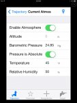
This will give you the same answer as the first way, but without using Altitude, as noted by my image above. Using Station Pressure in software turns off your ability to input altitude.
Finally you have Density Altitude, for that you just need the Density Altitude Figure. That can be determine at least 2 ways we use, (yes there are more)
1. Altitude
2. Temperature
or
1. Kestrel - which uses pressure, temp, humidity.
There is a long hand method but we don't need to get into that.
In order to get Density Altitude from your Kestrel, as this is about a Kestrel, you have to set the unit up to give you Station Pressure. Since you are using Station Pressure from the start, it makes sense to use Method number 2, Station Pressure, Temp, Humidity and not Method number one with BP.
Not everyone shoots the same range all the time. Some people travel, others shoot a variety of ranges local to them. Saying you found out your local range does "X" is like saying to someone, use 6 MPH for your wind because we found the yearly average to be that... while it may work for you. It's not a good practice for the masses.
While your explanation might work inside 1000 yards, you are still introducing errors and what happens when you to to 1 mile ? What happens when that person travels ? You have a .72 MOA error to start, plus you have .4 error if you put your humidity in the middle, plus you need a GPS or you can't use DA... the compromises don't make it a "Best Practice". Can you get it done, sure on your range you can, but it's a shortcut to solution for guys who are shooting the same place over and over. After the 2nd trip to Dan's Bang Steel Range do you even need anything beyond your data card. Hell you can write your dope on the side of your rifle and never sweat it. That is a given, but doesn't mean everyone should follow this example because you guys realize you can ignore the weather, aside from Temperature. You can ignore a lot of things.
There are 3 Ways to determine your firing solution when it comes to external conditions:
1. Barometric Pressure (corrected)
2. Temperature
3. Humidity
4. Altitude
You need these 4 inputs in order to make any ballistic software work.
Next you have
1. Station Pressure (absolute)
2.Temperature
3. Humidity
This will give you the same answer as the first way, but without using Altitude, as noted by my image above. Using Station Pressure in software turns off your ability to input altitude.
Finally you have Density Altitude, for that you just need the Density Altitude Figure. That can be determine at least 2 ways we use, (yes there are more)
1. Altitude
2. Temperature
or
1. Kestrel - which uses pressure, temp, humidity.
There is a long hand method but we don't need to get into that.
In order to get Density Altitude from your Kestrel, as this is about a Kestrel, you have to set the unit up to give you Station Pressure. Since you are using Station Pressure from the start, it makes sense to use Method number 2, Station Pressure, Temp, Humidity and not Method number one with BP.
Not everyone shoots the same range all the time. Some people travel, others shoot a variety of ranges local to them. Saying you found out your local range does "X" is like saying to someone, use 6 MPH for your wind because we found the yearly average to be that... while it may work for you. It's not a good practice for the masses.
While your explanation might work inside 1000 yards, you are still introducing errors and what happens when you to to 1 mile ? What happens when that person travels ? You have a .72 MOA error to start, plus you have .4 error if you put your humidity in the middle, plus you need a GPS or you can't use DA... the compromises don't make it a "Best Practice". Can you get it done, sure on your range you can, but it's a shortcut to solution for guys who are shooting the same place over and over. After the 2nd trip to Dan's Bang Steel Range do you even need anything beyond your data card. Hell you can write your dope on the side of your rifle and never sweat it. That is a given, but doesn't mean everyone should follow this example because you guys realize you can ignore the weather, aside from Temperature. You can ignore a lot of things.
It's so much simpler to just use the uncorrected pressure off a Kestral and skip the altitude. I've shot at Bang Steel, 2650MSL, TVP, 900 MSL, Peacemaker, 700 MSL or 850 MSL depending which range you ae on, Culpepper, 350 MSL and K&M, 200 MSL. Plug the numbers (uncorrected pressure, temp and humidity) into AB and the numbers are right on.
It looks like you clicked the Std. Atmosphere box which overrides the conditions you enter, like it does when you choose a bullet versus entering the dimensions manually. That's where the discrepancy is coming from.
I can see everyone's position here... Pinecone is saying if you don't have a Kestrel you can get it near enough with just a map and a thermometer, and LL is saying that a Kestrel will give you more accurate data without having to infer anything.
The way I see it, can you get by without a Kestrel? Of course. But they are cheap and it eliminates one source of error, so why not use one?
Sent from my Galaxy Nexus using Tapatalk
I ran every possible scenario I could think of to include intentionally doing it wrong to try and replicate a .1mil difference in firing solutions. The point of the entire exercise being that no matter how you do it, right or wrong,there is no way to get a .1 mil difference in firing solutions as was stated with the given parameters/circumstances.
Using a topo map with altitudes annotated along contour lines and a thermometer is figuring for DA, which is what the FDAC does and is what LowLight just explained and broke down in post #70
Pinecone has used the bang steel example several times but the facts are that the pressure can and does change not only in one location (as explained by Lowlight in the Rifles only example above) but especially if you travel to different locations. The bullet only cares about the air density it is in at the time it is fired. If you don't figure for it correctly the firing solutions you get/use will be off, garbage in , garbage out.
If I put it in just like he says, I get the .1mil difference (9.9 vs 10.0). The only thing that changes is with 29.92 the "pressure is corrected" box is checked and at 24.92 it isn't. Not saying that's correct, just that's how he got it. I don't really get what that proves though. It's just doing the correction for altitude sloppily by yourself vs. letting JBM do it when you can get the exact pressure to begin with from a Kestrel and not have to use an average, guess, or estimate for anything. I also don't get what that had to do with this discussion. If anything it proves that a Kestrel ISN'T a waste (which is what the thread asked about). I don't see why one would argue that using an average and a "close enough" altitude to work backwards is BETTER than a Kestrel. To paraphrase LL, doing it like that may work, but it's ass backwards.I ran every possible scenario I could think of to include intentionally doing it wrong to try and replicate a .1mil difference in firing solutions. The point of the entire exercise being that no matter how you do it, right or wrong,there is no way to get a .1 mil difference in firing solutions as was stated with the given parameters/circumstances.
If I put it in just like he says, I get the .1mil difference (9.9 vs 10.0). The only thing that changes is with 29.92 the "pressure is corrected" box is checked and at 24.92 it isn't. Not saying that's correct, just that's how he got it. I don't really get what that proves though. It's just doing the correction for altitude sloppily by yourself vs. letting JBM do it when you can get the exact pressure to begin with from a Kestrel and not have to use an average, guess, or estimate for anything. I also don't get what that had to do with this discussion. If anything it proves that a Kestrel ISN'T a waste (which is what the thread asked about). I don't see why one would argue that using an average and a "close enough" altitude to work backwards is BETTER than a Kestrel. To paraphrase LL, doing it like that may work, but it's ass backwards.
We are in agreement. I am glad you said this as it proves I am not loosing my mind and someone else "gets it".

Ok,
A bit of bad data going around this thread...
First Papa 30: the runs you did have one fatal flaw in the input data - this is a rerun I did here on your corrected version:

This is a run of your UNCORRECTED data:

Now, you have set the software to CHANGE THE ZERO TO THE PBR.
Therefore, one set of numbers is with zero at 447 m and the other at 443 m
That makes quite a bit of difference, believe it or not.
What would not have changed the result is if you tabled the total drop rather than the correction - ie turn off "Elevation Correction for Zero Range" (you also switched to standard atmosphere which made most difference - see later post).
Then the solution shows -11.9 mils of drop (corrected) and -12.4 (non corrected) (note:this is line of sight, doesn't matter what your zero is).
Now the 10.0 v 9.9 people. I assume you have used some other input?
I don't know what assumptions you are making, but I get a consistent 0.55 mil difference between the corrected pressure (29.92) and 'standard pressure at altitude' = 5000' which comes to (24.90) for the temp/pressure above (80/80)
Farmer
A bit of bad data going around this thread...
First Papa 30: the runs you did have one fatal flaw in the input data - this is a rerun I did here on your corrected version:
This is a run of your UNCORRECTED data:
Now, you have set the software to CHANGE THE ZERO TO THE PBR.
Therefore, one set of numbers is with zero at 447 m and the other at 443 m
That makes quite a bit of difference, believe it or not.
What would not have changed the result is if you tabled the total drop rather than the correction - ie turn off "Elevation Correction for Zero Range" (you also switched to standard atmosphere which made most difference - see later post).
Then the solution shows -11.9 mils of drop (corrected) and -12.4 (non corrected) (note:this is line of sight, doesn't matter what your zero is).
Now the 10.0 v 9.9 people. I assume you have used some other input?
I don't know what assumptions you are making, but I get a consistent 0.55 mil difference between the corrected pressure (29.92) and 'standard pressure at altitude' = 5000' which comes to (24.90) for the temp/pressure above (80/80)
Farmer
Last edited:
A bit more...
Yes, re-read what Pinecone was doing and I don't get how he gets 0.1 mils difference, as he was doing 80F/80% as well.
I suspect he didn't use "Standard conditions at altitude" like Papa 30 was (mistakenly) doing - let me explain...
There are four options:
1. Standard conditions = you input altitude, and machine models the RH, temp and pressure (it doesn't matter if you have corrected set) and uses it for the soln.
2. Corrected pressure = you input altitude, temp, RH and barometic (corrected) pressure. The machine models the station pressure based on atmospheric model and uses it for the soln. (Standard must NOT be set or that takes precedence)
3. Corrected not selected = you input altitude, temp, RH and station (absolute) pressure.
4. Corrected NOT selected = you input altitude, temp, RH and barometic (corrected) pressure - THIS IS CLEARLY WRONG.
Note: if you input the SAME VALUES for temp, pressure and RH in (2) or (3) as the standard model (1) assumes - you will get the same result!!
Let's take the cases in turn:
at 5000' using the standard model (calculated to be 41.2F, 0% RH and 24.90 Hg using " Std. Atmosphere at Altitude"): the drop (to line of sight) is 12.40 mils from (1) above.
at 5000' with the temp input as 41.2F, 0% RH and 24.9 and pressure uncorrected the drop (to line of sight) is 12.40 (tah dah!!) from (3) above
at 5000' with the temp input as 80F, 80% RH and 24.90 and pressure uncorrected the drop (to line of sight) is 11.86 mils (3) above (hotter air = less dense = less drop)
at 5000' with the temp input as 80F, 80% RH and 29.92 and the pressure corrected the drop (to line of sight) is 11.85 mils (2) above (model does good job of figuring out station pressure)
at 5000' with the temp input as 80F, 80% RH and 29.92 and the pressure uncorrected the drop (to line of sight) is 13.40 mils (case (4) and clearly WRONG for 5000' but correct for sea level)
at 5000' with the temp input as 80F, 80% RH and low pressure system of 29.2/989 HPa (on the weather channel) and the pressure corrected the drop (to line of sight) is 11.69.
So, the lower pressure system only makes about 0.16 mils difference.
But the BIG ISSUE isn't weather pressure - it's TEMPERATURE!!! If you use the standard model, the temperature could be a long way off.
As you see above, at 5000' the standard model assumes it's 41.4F. But if it's 80F, you are 0.55 mils out.
This is what is causing the some disagreement between the people above.
Some people clicked "Standard atmosphere at altitude" and it uses 41.4 - which makes 0.55 mils difference.
Changes in the weather makes differences to the range of 0.1 or so.
So, you're both right.
Ok, now what was the argument again???
I don't own a Kestrel, but I have to admit, with a Kestrel you don't need to make sure all this stuff is right to get a good soln.
Up until now, I use GPS (with pressure altimeter built in) and iPhone with AE Ballistics - but my spotter uses a Kestrel.
I might buy the AB version - I don't like the Horus one so much.
Another note on GPS. A normal GPS is NEVER accurate to 3m in altitude. That's why they have pressure based altimeters built in.
Although a 'normal' (i.e. no differential signal, no WAAS, no encrypted military channel) can get down to that sort of range in the X and Y coordinate, the Z is always less accurate.
The reason is pretty simple. Geometry. With a constellation of birds all around you, you can get a good spread in X and Y.
But with Z, the birds are all above you and inherently less accurate - if we could get signals through the earth, it would be better.
(I don't explain it well, but that's the main reason).
Cheers Farmer.
Here is something you might understand...
At Rifles Only which is 78ft above sea level, in one day we saw a swing in Density Altitude from 3000ft above sea to -2000 ft below sea level. (5000ft) That was in a 24 hour period. No altitude change, but a combination of a front with a drop in temperature. Pressure & Temperature.
If a shooter uses a Kestrel... in order to accurately read Density Altitude you have to use STATION PRESSURE. (This is uncorrected) Station pressure goes below the recorded barometric pressure (corrected)
We are shooting NOT READING THE WEATHER ON TV so we want information that useful to us, without having to carry both a tool for altitude (GPS) and a tool for reading the conditions, a Kestrel. We choose to use a Kestrel so you want to maximize that tool and that information. Density Altitude is a great single number as noted several times including your Dan Thread. DA readings can be taken directly from the Kestrel however you have to set to 0 reference altitude and 29.92 which gives the uses STATION PRESSURE. Not corrected barometric pressure.
See the picture I posted, Denver is 24.92 (roughly) yet one hour from my house I can show as low as 18" ... using that number plus temp I can successfully use a ballistic computer and shoot. I have done this including zeroing a rifle in CO, and traveling to OR with a 4000ft change in altitude. However I did not use Altitude and still was 100% successful.
What were the ACTUAL temp and pressure readings?
Pressure versus altitude is about 1" of Hg per 1000 foot altitude change. So for DA to change 5000 feet based on pressure. It would take a 5" pressure change. And unless that front was a hurricane, you did not see a pressure change like that.
And YES, you can go from 24" to 18" with short drive in the Rockies. BECAUSE YOU ARE CHANGING ALTITUDE. If you went from 5000 feet to 11000 feet, you will see that pressure change WITHOUT A CHANGE IN CORRECTED PRESSURE.
[forehead slap] I feel like I am eating crazy pills[/forehead slap] PLEASE, PLEASE, go back and READ what I wrote and READ the screen grab JBM charts from TOP to BOTTOM. I did exactly what you just said and the results are found in the screen grab posted for CORRECTED pressure. Guess what? The firing solutions ARE NOT .1mil difference, it's all explained and plain to see, even with pictures , above.
If after you go back and READ and LOOK at the charts posted and if it still isn't apparent to you, please follow LowLights advice in post #66
EDIT: I just know I will probably regret bringing this up but what the hell. GPS derived altitude readings can be quiet a bit off from actual altitude. You mentioned a 3m +/- accuracy which is a best case scenario and is for a physical point on the ground. If your GPS doesn't have a built in barometric altimeter, the GPS uses stored historical data which very likely isn't an exact measurement of the altitude you are at, its an approximation. And even if your GPS does have a built in Barometric altimeter, you need to adjust it like the kestrel if it allows you to, or know if it averages actual altitude data with GPS stored altitude data. I don't want this to turn into a GPS discussion but your thinking that you can use a GPS derived altitude and that it is 100% more accurate than an actual altimeter reading is also erroneous. Here is an article that illustrates how much this can vary and why. GPS and altitude for hang gliding and paragliding | Paragliding : Hang Gliding : Cross Country Magazine
I don't know why your results are so different. I saw the changes I posted. I will run it again and post screen shots.
And GPS actually gives a three dimension position. What is finds is the intersection of several spheres centered on several sats. If there are few sats in view, 3D location is degraded or possibly not available. But the altitude, with enough sats (4 actually) in view, is similar to horizontal accuracy.
GPS is used in surveying to find exact positions in 3D.
If you travel to different locations, you are also likely changing altitude.
Pressure changes with altitude.
I use Bang Steel as Dan posted the link to the actual official pressure readings for his area over a 9 month period of time.
Show me changes in pressure more than +/- 0.5" at any place, even in abnormal conditions. CORRECTED PRESSURE.
Pressure changes with altitude.
I use Bang Steel as Dan posted the link to the actual official pressure readings for his area over a 9 month period of time.
Show me changes in pressure more than +/- 0.5" at any place, even in abnormal conditions. CORRECTED PRESSURE.
If I put it in just like he says, I get the .1mil difference (9.9 vs 10.0). The only thing that changes is with 29.92 the "pressure is corrected" box is checked and at 24.92 it isn't. Not saying that's correct, just that's how he got it. I don't really get what that proves though. It's just doing the correction for altitude sloppily by yourself vs. letting JBM do it when you can get the exact pressure to begin with from a Kestrel and not have to use an average, guess, or estimate for anything. I also don't get what that had to do with this discussion. If anything it proves that a Kestrel ISN'T a waste (which is what the thread asked about). I don't see why one would argue that using an average and a "close enough" altitude to work backwards is BETTER than a Kestrel. To paraphrase LL, doing it like that may work, but it's ass backwards.
Not exactly.
What I did was use the PROVIDED pressure 24.92 (absolute) at a range at about 5000 feet (according to the poster) versus using the altitude as the input to JBM with the standard corrected pressure, which is 29.92".
You can do the same sort of thing with JBM by using actual altitude and corrected pressure changes from actual weather sources. As I have mentioned, I ran the numbers based on the highest and lowest pressure at the Bang Steel range over a 9 month period. And also came up with 0.1 mil change in come up.
But the BIG ISSUE isn't weather pressure - it's TEMPERATURE!!!
Bingo.
My point has been that having altitude and temp is close enough. Never said that a Kestral is not a good tool. Just that it is not the ONLY want to get there.
Heck, I just got a Leica 1600B. It gives me absolute pressure and temp.
And yes, you cannot use standard conditions at altitude, as they would then use the "standard" temperature.
Standard temperature at sea level is normally taken as 59F. It does depend on what "standard" you are using.
Standard conditions for temperature and pressure - Wikipedia, the free encyclopedia
Then they use the standard lapse rate, which we used 4.4F per thousand feet in aviation. And the atmosphere seldom adheres to the "standard" lapse rate.
Lapse rate - Wikipedia, the free encyclopedia
We have already acknowledged there is more than one way to skin the cat, been noted, more than once.
You way limits you and sets the kestrel up incorrectly as well the average joe is not going to buy a surveying GPS to align themselves with your way of thinking.
Also going from CO to OR was only a 4000ft change with no difference in temperature and moved the dope from 6.5 to 7.2. Using Station Pressure in a kestrel with AB it was dead on. One unit, no GPS and set up correctly for shooting. That is the key.
Setting it it up correctly for shooting, as it's been acknowledged there are several paths to the same solution but only 1 path gives you 2 answers with a single device, the smaller and lighter kestrel vs your "better", chosen way.
You're so married to your idea you'll defend this poor, inefficient method tooth and nail.
Going from 5000 to 9000 feet here in CO can change the DA from 8,000 to 12,000 even in fall, it's more than one thing, it's more than temp, as noted at Rifles Only, it's a combination, it's generally cooler higher up. Station Pressure accounts for more than one thing with a single number. Like DA does, so why use. Your method that needs a minimum of 4 values especially if you travel. You can't just cherry pick unless you stick to one location. It's a total of several conditions.
Actually I found your pressure swing to go .2 mils either way, .1 from center. That is 1 minute, now combine that 1 minute with other changes that follow like temp. Heck even the .4" of humidity now starts adding up. So your starting to stack errors in a game where we want to shave them.
Like I noted, use your way, but don't try selling it as better, it's a way, just not a very good way for the precision rifle shooter.
Ask yourself this,
What is the "Best Practice' and why would you want to turn people on to something that is not a Best Practice just because the math will work out that way.
There are a lot of things in Shootings have multiple paths to the same solution. The goal should be to give people the best route. If down the road they find because of where they shoot or how they shoot, they can take a shortcut, well then that is fine. But starting people off with a shortcut, especially one that introduces even small errors. (remembers errors compound) is a poor way of educating people.
In order to get a solution, you need Pressure, Temperature, Humidity, the fact you can use altitude and then correct the pressure to Barometric Pressure doesn't become an Ah Ha moment, it just means we have more than one path to the answer. Telling people to ignore Pressure in favor or Altitude is like saying, go to Cancun but stay away from the water, or worse, never showing them the water in the first place. Sure they can say they went to Cancun, and it was lovely, but when you ask them how the Beach was, they look at funny because they never saw it.
You're attempting to educate people in the wrong direction, like i said 5 + posts ago, you're ass backwards.
A Kestrel + Station Pressure = a smaller and lighter solution that gives you both valid data and the correct Density Altitude. There is really no need to think it about it any other way. In fact, its not just my opinion but clearly those who write modern ballistics computer software as they give you the ability to remove altitude by using Station or Absolute Pressure. This includes your LRF... so why look to end run that ? Just because you can, well as long as you add a GPS to your list of things.
Thanks for the explanation Lowlight. I have been adjusting my altitude on my 4500 AB based off my gps elevation wherever I was shooting and thinking I needed to do it to get the correct dope not realizing I was doing extra steps that we're not needed. I just finished setting my station pressure to 29.92 and not going to mess with it or the altitude again. It will make things much easier when I go to a new area/comp to shoot not having to worry about "adjusting" things to get the right dope
Thanks for the explanation Lowlight. I have been adjusting my altitude on my 4500 AB based off my gps elevation wherever I was shooting and thinking I needed to do it to get the correct dope not realizing I was doing extra steps that we're not needed. I just finished setting my station pressure to 29.92 and not going to mess with it or the altitude again. It will make things much easier when I go to a new area/comp to shoot not having to worry about "adjusting" things to get the right dope
Yeah. Extra step. That's what Lowlight has been saying.
In fact , I believe the real variable to ballistic equations is air density. This varies based on pressure and temp (and to a small amount on humidity). If we could invent a device that measured it directly, it's all we need. Every other variable is just a path to determining that.
All this argument is currently about how to determine air density. Lowlight is saying you just need station pressure and temp (I'm with him), whilst others say you can use 3 or more (eg altitude plus temp plus a corrected pressure and a complicated atmospheric model).
The Kestrel is one of the most straightforward ways out there.
From Pinecone:
This is true: And GPS actually gives a three dimension position. What is finds is the intersection of several spheres centered on several sats. If there are few sats in view, 3D location is degraded or possibly not available.
Not true: But the altitude, with enough sats (4 actually) in view, is similar to horizontal accuracy.
True, but...: GPS is used in surveying to find exact positions in 3D.
What is "exact"? Plus or minus what? In what dimension?
Sorry, but accuracy in the Z from a "normal" GPS is never as close as is X and Y. It doesn't matter how many times or ways you say it, it's just simply wrong.
And survey methods use post processing to get their accuracy (or differential techniques). This was in the centimeter region last time I was following GPS technology closely (part of my job today although more for time than position).
Farmer.
Doesn't GPS base altitude off a sphere? So it wouldn't give accurate altitude anyway. Or do modern device correct for it using the latitude? Sorry I know this isn't a 'How GPS Works' thread.
Sent from my Galaxy Nexus using Tapatalk
Sent from my Galaxy Nexus using Tapatalk
Doesn't GPS base altitude off a sphere? So it wouldn't give accurate altitude anyway. Or do modern device correct for it using the latitude? Sorry I know this isn't a 'How GPS Works' thread.
Sent from my Galaxy Nexus using Tapatalk
Define accurate.
Altitude is based on the WGS 84 geoid (the model of the earth that GPS uses).
The world isn't a sphere, but more like a prolate spheroid.
That's a whole other discussion - just what *is* altitude? Against what?
There are better places to hold this discussion.
Sent from my iPad using Tapatalk HD
Pinecone and everyone else who is asking GPS questions, please scroll up to post #68 and click on the link I provided. READ the entire article, its a 5 min read but it will answer all of the questions I've seen that have been asked in reference to GPS.
Pinecone.: Do not confuse GPS surveying grade equipment with your handheld commercial unit. The reason why they can use it down below the 3meter range is beyond this conversation. However, for those interested, Google
Differential GPS" and or "GPS Surveying". As mentioned, and explained in the article, GPS is accurate on the X and Y axis on a good day , down to the +/- 3 meter range, the Z axis (vertical) is +/- 45 meters. To compound these issues, one also has to figure for HAE ( Height above ellipsoid) depending on where you are on the planet and the other variables that are explained in the article linked in post #68.
There is a reason why precision GPS guided munitions and precision GPS guided bundle systems all have and rely on a barometric altimeter for determining accurate altitude in conjunction with a GPS system.
Because I know some of you are lazy and won't take the time to scroll up thread, here is the link. Read it, you WILL increase your knowledge on GPS.
GPS and altitude for hang gliding and paragliding | Paragliding : Hang Gliding : Cross Country Magazine
Awesome read on that article Papa, thanks. My uncle (a surveyor) tried explaining to me some of the errors GPS has associated with it concerning altitude, but was missing some of the details this article broke down. That might be a good read for the "Fieldcraft" sub-forum as well.
So guys...help me out....
There is no doubt you all are more experienced at this then I ever will be but I would like to step into the electronic world for my long range shooting. My problem is that I am not a gadget person at all and small screens & buttons are more work than fun to me but as long as the path (program) is user friendly, I'm good. I have to travel to shoot long and with ammo being what it is "grabbing a case and going shooting" is not a great option.
Kestral products are not inexpensive and I'm not sure what device I need to connect to with the bluetooth option. I have an Iphone but am confused about if it can do what I need or not. I know it has ballistic apps but not sure where to get the "on location" environmental data. Seems like kind of a pain to go to all these different sites for data and try to get it all entered in correctly.
Can you make an economical recommendation on what basic set-up to buy?
I thought this was about a kestrel. My vote is a kestrel is the best money you can spend on your shooting gear!!!!!!!!! Now just like different postions in shooting say off a bench very stable and very precise but not quick to setup nore very mobile. Now standing not so stable and not so precise but very quick to setup and very mobile. Each of these there is a trade off do you want quick or precise. The same goes for ballistic calculations. The more short cuts you take the more error in your solution. The best thing to do is be able to collect data in the field and calculate to your current enviroment anything less is NOT as accurate. And i should state data collected that is not correct or accurate is even worse. Now once you can make all the solutions very accurately in any condition at any elevation then work on methods to short cut because then you have an accurate base line.
I was using smart phone with applied ballistics and getting weather data from a weather app. Was close but never right on. So the decision was do i just buy a new kestrel to get weather or go with the model with the applied ballistics.
I bought the 4500 with applied ballistics software. None of the bs of connecting phone to meter one unit. expensive? Yes it is. But with the price of ammo bought or loaded and limited range time it is worth it.
My experience with the unit is. We shot my budies 338 lapua here in michigan about 1200 ft elevation tuned the kestrel to it at 1000 yrds. We traveled to wyoming elevation of about 5500 ft and shot at 1000 yrds spot on. Shot at 1900 yrds and also spot on. And then back to michigan shot at 1000 yrds and come ups were correct. Just last weekend the 1000 yrd come up for my 6mm was different by 1/2 moa from saturday morning to sunday morning. The nice part is you just turn the unit on and it uses the data it gathers no need to input anything. Now everyone should also know what the data is and have another method to calculate come ups. Or you refrence your data book.
Huh, this is interesting. I travel all over the place and I use a Kestrel 4000NV and use DA 99% of the time. It seems to work very well for me. Recently I started logging in all the other enviro conditions in my log book. That way I can start looking into patterns later on to learn more about environmental changes. For now DA works for me as Im pretty much only shooting my 20" 6.5 creedmoor out to about 1300 yds total.
It has been a long time since I setup my Kestrel but im fixing to see if it is setup properly. If its not thenI would be scared to change it as my firing solutions have been pretty accurate I believe. We shot a rock the other day at 1330 yds here in new York, my solution was 19 mils up and my first shot impacted .1-.2 mils low. A second shot put it dead on with a click or two.
Funny thing about that is that the last ELR shot I got to make with that rifle was in west texas and the distance was 1330 yards again. This time my solutions was 16.3 mils I believe And it was also a click off. My MV or BC might need a little tweaking but I'm never far off. Texas was summer and the New York shot was just recently. And with a 3 mil difference I would say the environmental changes at LR are significant. I'm no expert and to be honest I really don't understand a lot of the different ways of doing the same thing. I use the DA mostly and I'm happy. I really want to learn all the methods to be the best I can be. I will get back with how my Kestrel is setup. I sure hope I have had it right cause if not, I'm really confused. LL thanks for the info. I take this VERY seriously and have always wanted to do it right the first time. The KEstrel has saved me a lot of ammo and got me a lot of first round hits at distance.
Understand this, the Bluetooth Kestrel will not work with an Apple Product. Apple limits the devices that can connect to an iPhone via Bluetooth. The protocol is wrong so you can't talk to a Kestrel with your iPhone Ballistic Apps.
The bare bottom Kestrel I recommend is the 4000, if you watch certain website at times you can find them for well under $200.
The Applied Ballistics Kestrel is probably the best single source solution for both right now. Apps are great, but they have limits regardless of what you have read. And bringing your phone to the field to use as a shooting aid is a tricky proposition. Anecdotal here, but worth it:
Traveled to K&M in Florida, had the GAP Bravo 6 Delta with me, and was never shot. My ammo, loaded by George was waiting for me. The first two days the weather was perfect, zeroed the rifle, doped it to 800, and chonographed it. First day of the match, down poured, all weekend. So my phone never left the car. What I did was back everything up to paper, and used post it notes to engage each stage. I never broke out a single piece of electronics during the match.
But the AB Kestrel is a good buy, two birds with one stone, solid software that draws directly from the Kestrel. Or you can use it as just a weather meter. They have future proofed it, allowing them to update not only the software but the firmware. So you have a good unit that will not be obsolete in less than a year.
If you get a unit like that, the bluetooth is worth it. Really, if you have already invested in the high dollar stuff, like a Trimble Nomad, FFS, etc, getting the Bluetooth is not an issue. If you are trying to save money, chances are, you are not buying the most expensive stuff that takes advantage of the Bluetooth to begin with. (not talking about the AB Version, the Bluetooth serves a difference function there)
If you are using an App, iPhone, etc, don't waste your time with the bluetooth.
RobertB, if you are not changing your settings every time you travel odds are it is set up right
So guys...help me out....
There is no doubt you all are more experienced at this then I ever will be but I would like to step into the electronic world for my long range shooting. My problem is that I am not a gadget person at all and small screens & buttons are more work than fun to me but as long as the path (program) is user friendly, I'm good. I have to travel to shoot long and with ammo being what it is "grabbing a case and going shooting" is not a great option.
Kestral products are not inexpensive and I'm not sure what device I need to connect to with the bluetooth option. I have an Iphone but am confused about if it can do what I need or not. I know it has ballistic apps but not sure where to get the "on location" environmental data. Seems like kind of a pain to go to all these different sites for data and try to get it all entered in correctly.
Can you make an economical recommendation on what basic set-up to buy?
The cheapest route is to measure temperature and pressure directly with a thermometer and altimeter. You can guess at humidity because it doesn't matter much. Then plug it all into a $5 ballistics app (take your pick - there are several good ones) on your phone. That will save you a few bucks over a kestrel and do the job pretty much just as well, albeit without the bells and whistles.
The cheapest route is to measure temperature and pressure directly with a thermometer and altimeter. You can guess at humidity because it doesn't matter much. Then plug it all into a $5 ballistics app (take your pick - there are several good ones) on your phone. That will save you a few bucks over a kestrel and do the job pretty much just as well, albeit without the bells and whistles.
That was my original point.
Not that the Kestral is not useful, but that there are cheaper ways of getting pretty darn close.
I have found this thread to be very useful. The OP asked the very question that has been going through my mind for some time and I am going to see if I can find a Hide vendor that can get me where I want to go. A Kestrel would be fine but going to explore the lower cost options as well. If it gets close to a Kestrel in price or I find a good deal on one, I'll have what I need.
Been doing a lot of looking around, the 4500NV is a pretty nice piece of kit.
Been doing a lot of looking around, the 4500NV is a pretty nice piece of kit.
We have already acknowledged there is more than one way to skin the cat, been noted, more than once.
You way limits you and sets the kestrel up incorrectly as well the average joe is not going to buy a surveying GPS to align themselves with your way of thinking.
Also going from CO to OR was only a 4000ft change with no difference in temperature and moved the dope from 6.5 to 7.2. Using Station Pressure in a kestrel with AB it was dead on. One unit, no GPS and set up correctly for shooting. That is the key.
Setting it it up correctly for shooting, as it's been acknowledged there are several paths to the same solution but only 1 path gives you 2 answers with a single device, the smaller and lighter kestrel vs your "better", chosen way.
You're so married to your idea you'll defend this poor, inefficient method tooth and nail.
Going from 5000 to 9000 feet here in CO can change the DA from 8,000 to 12,000 even in fall, it's more than one thing, it's more than temp, as noted at Rifles Only, it's a combination, it's generally cooler higher up. Station Pressure accounts for more than one thing with a single number. Like DA does, so why use. Your method that needs a minimum of 4 values especially if you travel. You can't just cherry pick unless you stick to one location. It's a total of several conditions.
Actually I found your pressure swing to go .2 mils either way, .1 from center. That is 1 minute, now combine that 1 minute with other changes that follow like temp. Heck even the .4" of humidity now starts adding up. So your starting to stack errors in a game where we want to shave them.
Like I noted, use your way, but don't try selling it as better, it's a way, just not a very good way for the precision rifle shooter.
Nobody has ever said a 4000 foot change in altitude would not change the come up significantly. Just that the 4000 foot change in altitude is MUCH more of a difference than the difference in baro pressure between the two places. Using the same temp, humidity, and 29.92" pressure, I get a change from 9.3 to 10.2 mils for my .308 load.
And wow, a change in altitude from 5000 to 9000 feet in altitude changes the DA from 8000 to 12000. Let's see, a change of 4000 feet in actual altitude (9000 - 5000) results in a 4000 foot (12000 - 8000) foot change in density altitude. Amazing. That actually HELPS my case. As the ALTITUDE CHANGE and TEMP are what made the difference.
Yes, it is cooler at higher altitude. That is the lapse rate. But density altitude assumes a decrease in temp as you go up. If the temp does not get cooler as you change to a higher altitude, the density altitude goes up faster than the actual altitude.
No one EVER said to ignore temp.
I have found this thread to be very useful. The OP asked the very question that has been going through my mind for some time and I am going to see if I can find a Hide vendor that can get me where I want to go. A Kestrel would be fine but going to explore the lower cost options as well. If it gets close to a Kestrel in price or I find a good deal on one, I'll have what I need.
Been doing a lot of looking around, the 4500NV is a pretty nice piece of kit.
Look at the Weatherhawk 350 for a lower cost option. Here is the SH review of it. I also use this model and the review is spot on.
WeatherHawk WM-350: An Alternative to the Kestrel 4500NV
Similar threads
- Replies
- 3
- Views
- 477
- Replies
- 0
- Views
- 330
- Replies
- 0
- Views
- 242
- Replies
- 4
- Views
- 403
- Replies
- 1
- Views
- 294
