

I plan on doing some testing out to about 1500yds.,and my rangefinder(bushnell elite 1500),quits at about 1000yds.So my only options right now are my garmin gps,or google earth.Are these methods very accurate.I have a program that can figure the distance based on coordinance.Just curious if anyone here ever uses google earth,and how accurate it is?Here is a program to range with coordinates http://pages.sbcglobal.net/jomoncada/distance/Dist2Points.xls in case anyone wants to try it.
- Thread starter KQguy
- Start date
You are using an out of date browser. It may not display this or other websites correctly.
You should upgrade or use an alternative browser.
You should upgrade or use an alternative browser.
Re: How accurate is Google Earth for rangefinding?
I checked the distances on Google Earth from the tower at Rifles Only to some of the longer KD berms, and found them to be quite accurate. And I had double-checked those distances with a GPS and a very accurate PLRF-10.
Of course, once you get beyond 1000 yards, you're getting pretty intolerant of range error. With a .308 at 1000 yards, for example, a 20 yard range error translates to a miss on a 20 inch target.
Re: How accurate is Google Earth for rangefinding?
Lindy,
Will google earth and a handheld gps have the same accuracy,or will one be better than the other?I have both,so I will use which ever one is better.BTW,how close were your readings when you ranged using all 3 methods.
Lindy,
Will google earth and a handheld gps have the same accuracy,or will one be better than the other?I have both,so I will use which ever one is better.BTW,how close were your readings when you ranged using all 3 methods.
Re: How accurate is Google Earth for rangefinding?
My readings were all within 5 yards IIRC.
In general, I'd expect a good handheld GPS to be the most accurate, especially if you put it in a mode where it averages multiple readings.
However, trying to compare ranging accuracy with multiple methods is a lot like the old saying that, "A person with one watch knows what time it is, and a person with two watches is never sure."
Of course, if you can't get the GPS to where the target or FFP are, then you have to use what you can.
Normal variation in muzzle velocity is enough to cause misses beyond 1000 yards, so my policy is to be prepared to execute followup shots.
Re: How accurate is Google Earth for rangefinding?
I would think ranging with an expensive rangefinder,like a PLRF10 would be the most accurate,but it will be a while before I can come up with the cash,so I have to settle for the next best thing.I will be shooting at steel,so I can go to the target,and get the exact location of the target.I am just doing this to collect some good dope for yardages beyond 1000.Seems like whenever I shoot beyond 1000,I come up short,I just need to get some good data,so I can get my Exbal to match up to the curve of my 7mmWSM.I was shooting a mile the other day,and was coming up a good 3 moa short,going off exbal.
I would think ranging with an expensive rangefinder,like a PLRF10 would be the most accurate,but it will be a while before I can come up with the cash,so I have to settle for the next best thing.I will be shooting at steel,so I can go to the target,and get the exact location of the target.I am just doing this to collect some good dope for yardages beyond 1000.Seems like whenever I shoot beyond 1000,I come up short,I just need to get some good data,so I can get my Exbal to match up to the curve of my 7mmWSM.I was shooting a mile the other day,and was coming up a good 3 moa short,going off exbal.
Re: How accurate is Google Earth for rangefinding?
Just throwing this out there, but why not stand half way and use your rangefinder towards the target and also towards where you are shooting from and add them up.
Just throwing this out there, but why not stand half way and use your rangefinder towards the target and also towards where you are shooting from and add them up.
Re: How accurate is Google Earth for rangefinding?
PLRF + 1
I laugh though, to picture you with such technology...
PLRF + 1
I laugh though, to picture you with such technology...
A
Augustus
Guest
Re: How accurate is Google Earth for rangefinding?
I have a Trimble Nomad loaded with 1 meter resolution aerials for my whole state. A 32 gig CF held the whole state with room to spare. Range finding is very accurate if you can identify a feature at the point of interest.
I have a Trimble Nomad loaded with 1 meter resolution aerials for my whole state. A 32 gig CF held the whole state with room to spare. Range finding is very accurate if you can identify a feature at the point of interest.
Re: How accurate is Google Earth for rangefinding?
<div class="ubbcode-block"><div class="ubbcode-header">Quote:</div><div class="ubbcode-body">I was shooting a mile the other day,and was coming up a good 3 moa short</div></div>
Expecting precise elevation predictions from a ballistic program presupposes a few things, some of which are difficult to know, and some of which cannot be known precisely.
You must have precise knowledge of the velocity of each shot, well beyond the ability of most chronographs to measure even the average muzzle velocity of a group of shots, and you must know the temperature response of the muzzle velocity of your load.
You must know the real ballistic coefficient of the bullet you are shooting, which not only changes with velocity, but also varies a bit from bullet to bullet.
You must have carefully calibrated the click value of your scope, so that you know precisely what elevation you are dialing. And that value may not be linear, so measuring it over just one range is insufficient.
You must take into consideration the Eötvös effect, what most people refer to, but isn't, coriolis effect.
You must take into consideration the elevation variation introduced by headwind or tailwind components, which means that you must have some means of measuring those components over the entire course of the trajectory.
And, of course, we've already mentioned the range problem.
What I'm trying to say is that at the range you are talking about, I'd be astonished if an uncorrected program produced a prediction within 3 MOA.
The program I use the most, Field Firing Solutions, has a method of tailoring the program solution to match field data, though, so the next time I shot at that distance, it would produce better predictions.
Re: How accurate is Google Earth for rangefinding?
<div class="ubbcode-block"><div class="ubbcode-header">Originally Posted By: lonewolf83</div><div class="ubbcode-body">Just throwing this out there, but why not stand half way and use your rangefinder towards the target and also towards where you are shooting from and add them up. </div></div>
I have done that before,as long as the ground is flat.Sometimes the ground between the target and shooting position is too low,and you can't see the the target to range it,then you are also getting into angles,that could throw the distance off,since you would be ranging uphill at both targets.The gps will give you the straight across distance.
Re: How accurate is Google Earth for rangefinding?
O.K.,the last post got me thinking about shooting at steep angles.Let's say you were shooting uphill,or downhill(on a pretty good angle),and you got your distance off Google earth,or a gps.Am I thinking right by saying you would not have to factor in the angle of the shot,since your distance was ranged in a straight line,and not ranged on the angle,like you would get from a LRF.
O.K.,the last post got me thinking about shooting at steep angles.Let's say you were shooting uphill,or downhill(on a pretty good angle),and you got your distance off Google earth,or a gps.Am I thinking right by saying you would not have to factor in the angle of the shot,since your distance was ranged in a straight line,and not ranged on the angle,like you would get from a LRF.
Re: How accurate is Google Earth for rangefinding?
At extended distances and significant angles - when you're talking about a shot over 1500 yards - you must take three things into consideration:
1. The actual distance through the air, to compensate for the air density of the shot.
2. The angle, so that you can compensate for the difference in gravitational effect from a flat shot.
3. You may also have to compensate for the difference in air density between the firing position and the target. For example, if the shooter is at 3000 feet, and the target is at 4000 feet, the difference in air density on a long shot is significant.
Most ballistic programs will account for the first two factors, but none I know of accounts for the third.
For more information on inclined shooting, see:
Inclined Fire Explained
Bryan Litz' book Applied Ballistics for Long Range Shooting also has good information about this subject. I recommend his book to anyone who is shooting at extra-long ranges.
Re: How accurate is Google Earth for rangefinding?
no tat good.
no tat good.
Re: How accurate is Google Earth for rangefinding?
Well someone used it on a thread over in the bear pit, Look for "new range in texas".... They used the ruler on google and ranged a known 1000 meter range... google got it right.
Well someone used it on a thread over in the bear pit, Look for "new range in texas".... They used the ruler on google and ranged a known 1000 meter range... google got it right.
Re: How accurate is Google Earth for rangefinding?
<div class="ubbcode-block"><div class="ubbcode-header">Originally Posted By: lonewolf83</div><div class="ubbcode-body">Just throwing this out there, but why not stand half way and use your rangefinder towards the target and also towards where you are shooting from and add them up. </div></div>
50 points for pointing out the obvious fix!!!
I seem to remember something similar recommended for land navigation when visibility is limited. You double your distance by looking BOTH ways...
Re: How accurate is Google Earth for rangefinding?
GPS is 15 meter accuracy <span style="font-style: italic">or less</span> - the US Gov doesn't want civilians using the accurate channel - have heard it could be off by as much as 50 meters.
Google Earth has proven so far to be spot on the money vs my Leica 1200 - EXACTLY....1237 yards to an embankment from my house and 1237 yards via Google Earth...
Re: How accurate is Google Earth for rangefinding?
Just use it for a rough estimate. Then get out and measure for a true distance. Thats what I do. Google earth is a good tool, but its just a tool. Nothing beats getting out and running a tape to make sure you have the distance you want or need.
Howdy.
Just use it for a rough estimate. Then get out and measure for a true distance. Thats what I do. Google earth is a good tool, but its just a tool. Nothing beats getting out and running a tape to make sure you have the distance you want or need.
Howdy.
Re: How accurate is Google Earth for rangefinding?
<div class="ubbcode-block"><div class="ubbcode-header">Originally Posted By: ArcticLight</div><div class="ubbcode-body">GPS is 15 meter accuracy <span style="font-style: italic">or less</span> - the US Gov doesn't want civilians using the accurate channel - have heard it could be off by as much as 50 meters.
Google Earth has proven so far to be spot on the money vs my Leica 1200 - EXACTLY....1237 yards to an embankment from my house and 1237 yards via Google Earth... </div></div>
Id rather say 15 meters or better accuracy. Got garmin software + detailed terrain maps in my Nokia E75 phone w/ internal GPS. Even phone can do 15 yds easily. At least compared to map details, like ditch junctions etc.
Got also google maps mobile version in phone but havent never really tested it.
European Galileo -satnav should give yd or better with normal handheld consumer <span style="text-decoration: underline">friendly priced</span> (edit) devices btw.
Re: How accurate is Google Earth for rangefinding?
GPS accuracy depends on the unit. Something like an E-Trex (or similar everyday unit) will get you you within 10 meters at times. Sub-meter accuracy is readily available to the general public, it just costs a more money and is rarely needed.
GPS accuracy depends on the unit. Something like an E-Trex (or similar everyday unit) will get you you within 10 meters at times. Sub-meter accuracy is readily available to the general public, it just costs a more money and is rarely needed.
Re: How accurate is Google Earth for rangefinding?
I'm figuring that a 15yd difference in distance estimate works out to about 15" of drop at 1000yd (.280, 139SST at 3000fps), or between 1 and 2MOA. Holding beltbuckle, it's still very likely to be a hit; 1.5MOA high or low.
I think we overestimate the value of calculations.
Even the most precise are comparable to plausible fiction once one factors in issues like input data inaccuracy and covert environmental variances. First shot hit probabilities based on calcs could easily be off by 1 to 2MOA in a real world application.
Greg
Re: How accurate is Google Earth for rangefinding?
<div class="ubbcode-block"><div class="ubbcode-header">Quote:</div><div class="ubbcode-body">Even the most precise are comparable to plausible fiction once one factors in issues like input data inaccuracy and covert environmental variances.</div></div>
Not to mention normal variation in muzzle velocity.
First round hits at extended ranges are the exception, not the norm.
Re: How accurate is Google Earth for rangefinding?
Google Earth has been 100% accurate when compared to my Leica CRF 1200.
Ranging from my condo in downtown Vancouver to other very distinct apartment high-rises across the way has proven exact to within ±1 yard (as far out as 1300 yds).
I've even done driving tests from one stop sign to another stop sign (several kms away) on rural country roads and GE has proven accurate against my odometer.
Re: How accurate is Google Earth for rangefinding?
It is not possible to be 99.9% + (or remotely close on a regular basis) accurate ranging distances with Google Earth. Anyone using satellite imagery to calculate short, precise distances for shooting, etc. has little business shooting at anything other than KD ranges.
It is not possible to be 99.9% + (or remotely close on a regular basis) accurate ranging distances with Google Earth. Anyone using satellite imagery to calculate short, precise distances for shooting, etc. has little business shooting at anything other than KD ranges.
Re: How accurate is Google Earth for rangefinding?
<div class="ubbcode-block"><div class="ubbcode-header">Originally Posted By: matchking</div><div class="ubbcode-body">It is not possible to be 99.9% + (or remotely close on a regular basis) accurate ranging distances with Google Earth. Anyone using satellite imagery to calculate short, precise distances for shooting, etc. has little business shooting at anything other than KD ranges. </div></div>
i don't quite understand what you are saying. i have used it and made hits on a target close to 1500 yards. actually, i used my gps to get the range, made my shots, came home and entered the cords into google earth and sure as shit, my target was in the exact position as was my shooting position and the measurement measured the exact same. i have also used a lrf from a landmark to a landmark about 650 yards away. i marked my location on my gps as well as the landmark i was ranging. the gps distance was the same as my lrf gave me and google earth also confirmed.
i'd use what ever i had available to get a range. if all i had was google earth, i'd use that information before i made a wild ass guess.
Re: How accurate is Google Earth for rangefinding?
Doing a Google search for "google earth coordinate accuracy" may give you an idea of what he is referring to.
Doing a Google search for "google earth coordinate accuracy" may give you an idea of what he is referring to.
Re: How accurate is Google Earth for rangefinding?
<div class="ubbcode-block"><div class="ubbcode-header">Originally Posted By: Lindy</div><div class="ubbcode-body">Doing a Google search for "google earth coordinate accuracy" may give you an idea of what he is referring to.
</div></div>
again, it is probably much closer than a wag. my results have been very accurate in position and distance.
Re: How accurate is Google Earth for rangefinding?
First, what kind of GPS are you using? I am assuming that it gives you distances in feet (not .1 mile increments).
If anyone collects coordinates with a GPS and then enters those coordinates in a GIS program (ArcView, etc.) or other map software (Terrain Navigator, etc.) it should give you the exact same distance (doesn't mean it is correct/true distance). If not, something is wrong with the GPS or the program.
With that said, GPS error (we'll say greater than 5 meters at each point) combined with slope/terrain differences does not make for precise info. GPS readings (provided they are in feet or meters) should make for more accurate distance calculations than looking at an aerial image and guessing exactly where your two points are though.
I would take GPS distance over aerial photo measurement anyday, but would prefer to use niether when making a shot.
Re: How accurate is Google Earth for rangefinding?
Of course it's much closer than a WAG. I think Matchking was responding to the assertion by pazzo that it's "100 percent accurate", when compared to his Leica 1200.
Let's examine that claim.
How accurate is the Leica 1200? Sure, when it gets a reading, it displays range to the yard. Is it accurate to a yard?
Nah, it isn't.
Leica claims an accuracy of a half percent when ranging objects past 800 yards. At 1000 yards, that gets you claimed accuracy within 5 yards.
The Vectronix PLRF-10 claims accuracy to +/- 2 meters, and it's a $3500 instrument.
Is the Google Earth data accurate with 5 yards? Sometimes, but sometimes not.
Is GPS data accurate to within 5 yards? Sometimes, but sometimes not.
Is your automobile odometer accurate within 5 yards? Oh, hell no.
I think you see where I'm going. One hundred percent accuracy is simply not achievable. If you want 99.9 percent accuracy, you're going to have to go to expensive professional surveying equipment.
The question is how accurate one needs to be. I've checked Google Earth against good GPS and very good laser rangefinders, including a PLRF-10, and found agreement which I believe within 5 yards at 1000 yards.
That's pretty good for most shooting purposes.
Re: How accurate is Google Earth for rangefinding?
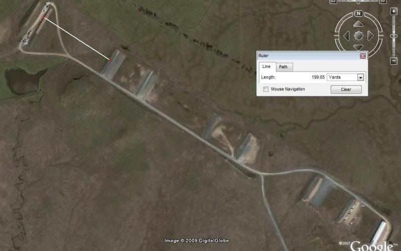
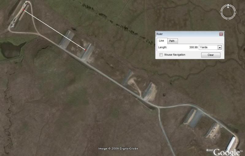
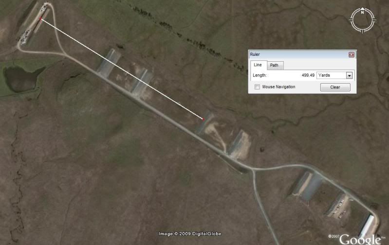
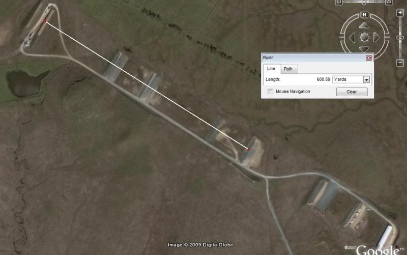
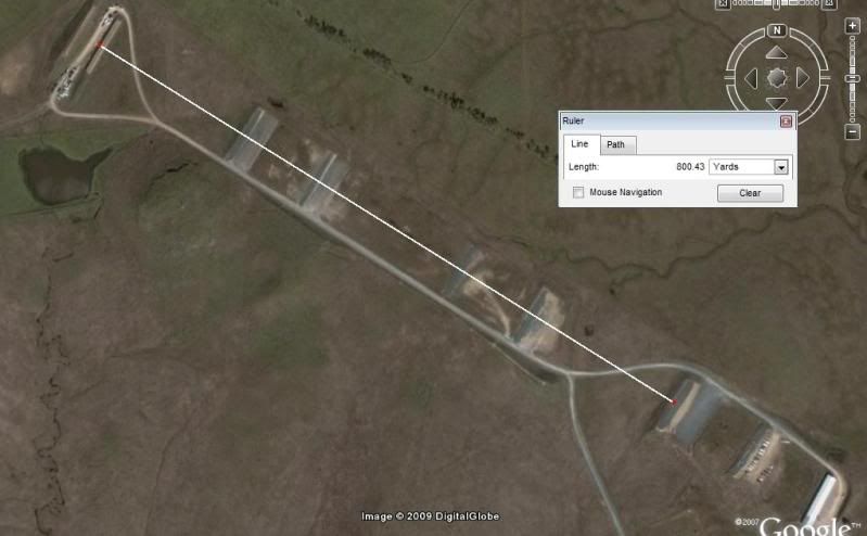
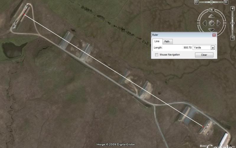
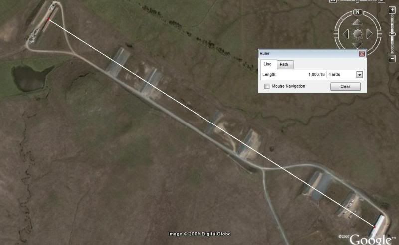
Using a known length(SS394 USS Razorback, 311 feet in length) and a Google Earth image(USS Razorback moored in the Arkansas River in downtown Little Rock, AR dated 12/29/05), I came up with a length of 304 feet. That gives an accuracy of -2.25%. That includes the margin of error of the computer monitor itself may impart, so Google Earth could be a little better or a little worse. Either way it's better than eyeballing it, at least as good or a little better than using mildots to estimate range from landmarks or locations and a little less accurate than a good laser range finder. On the other hand I have found Google Earth to be off in coordinates(1/4 mile in some cases) depending on the location and when the imagery was taken.
Most likely you wouldn't have the time or the capability to look up Google Earth and get the distance in real life and it's alway possible since the imagery Google Earth uses is several years old in some cases that landmarks in the images can be gone or moved and the terrain changed by now. On the other hand it is a good tool for someone to look at prior to any deployment to get a good idea of the terrain and landmarks so they can have some idea of where to setup if there isn't any current imagery available from other sources.
Re: How accurate is Google Earth for rangefinding?
Ahh, but how accurate is that measurement of the USS Razorback?
An old saying is that a man with one watch knows what time it is, but a man with two watches is never sure. It seems to be the same with linear measuring equipment...
Ahh, but how accurate is that measurement of the USS Razorback?
An old saying is that a man with one watch knows what time it is, but a man with two watches is never sure. It seems to be the same with linear measuring equipment...
Re: How accurate is Google Earth for rangefinding?
i agree lindy with nothing really being 100% accurate. our gps units are better than a hundredth of a foot accurate but that is still not 100% accurate.
i just didn't get this part " Anyone using satellite imagery to calculate short, precise distances for shooting, etc. <span style="color: #FF0000">has little business shooting at anything other than KD ranges</span>."
if the only means i have to estimate range is only accurate to say 15 yards, should i not go out and have fun trying to hit a target? i would not promote shooting at an animal using google earth as a ranging tool but for targets, i don't see why not.
Re: How accurate is Google Earth for rangefinding?
The vast majority of people in the world lack the photogrammetry skills to estimate ranges from aerial imagery. I consider my photogrammetry skills as top-notch, yet I do not use them to estimate target distances.
The vast majority of people in the world lack the photogrammetry skills to estimate ranges from aerial imagery. I consider my photogrammetry skills as top-notch, yet I do not use them to estimate target distances.
Re: How accurate is Google Earth for rangefinding?
<div class="ubbcode-block"><div class="ubbcode-header">Originally Posted By: matchking</div><div class="ubbcode-body">The vast majority of people in the world lack the photogrammetry skills to estimate ranges from aerial imagery. I consider my photogrammetry skills as top-notch, yet I do not use them to estimate target distances. </div></div>
so you wouldn't give it a go on a steel target about 1500 yards away if all you had was google earth to range it? you'd just pack your gear and go home?
Re: How accurate is Google Earth for rangefinding?
Google earth range measuring matches known distances I've lased at my local range, at least better than milling does!
Google earth range measuring matches known distances I've lased at my local range, at least better than milling does!
Re: How accurate is Google Earth for rangefinding?
If thats all you have and its safe, go for it. Matchking uses aerial photos more than most on here, take his advice.
If thats all you have and its safe, go for it. Matchking uses aerial photos more than most on here, take his advice.
Re: How accurate is Google Earth for rangefinding?
Re: How accurate is Google Earth for rangefinding?
<div class="ubbcode-block"><div class="ubbcode-header">Originally Posted By: pwc001</div><div class="ubbcode-body">If thats all you have and its safe, go for it. Matchking uses aerial photos more than most on here, take his advice. </div></div>
you post is a bit contradictory. go for it but take his advice and stick to known distance ranges?
Re: How accurate is Google Earth for rangefinding?
I have found cases where the google earth worked better than a $12,000 Leica LRF.We were at the range,and ranged a target at 1717 yds,I went home and google earthed the target we ranged,and came up with 1637 yds.After taking a close look,I realised we were hitting the tree's behind the target,wich ranged 1717 yards.I think when trying to range ELR,even the expensive rangefinders can be questionable,espescially when trying to range smaller targets from extremely long distances.From my experiences lately,I have found google earth to be very accurate.
I have found cases where the google earth worked better than a $12,000 Leica LRF.We were at the range,and ranged a target at 1717 yds,I went home and google earthed the target we ranged,and came up with 1637 yds.After taking a close look,I realised we were hitting the tree's behind the target,wich ranged 1717 yards.I think when trying to range ELR,even the expensive rangefinders can be questionable,espescially when trying to range smaller targets from extremely long distances.From my experiences lately,I have found google earth to be very accurate.
Re: How accurate is Google Earth for rangefinding?
At those ranges, laser rangerfinders which aren't mounted on an M1A1 Abrams are going to be problematic.
It's always a good idea to take several ranges on a given target at long ranges. I try to tap around the edges of the target, which often reveals which are hitting the target and which are hitting something in front of or behind the target.
However, with the possible exception of the special operations guys who are lugging a Toughbook with a satellite link, using Google Earth in the field may be a bit difficult...
Re: How accurate is Google Earth for rangefinding?
Have any of you tried Google Maps, instead of Google Earth to range stuff?
Just wondering if it works too. I myself haven't given it a try yet.
Have any of you tried Google Maps, instead of Google Earth to range stuff?
Just wondering if it works too. I myself haven't given it a try yet.
Re: How accurate is Google Earth for rangefinding?
The photo illustration is nice. I guess you could use it fairly accurately if you were shooting from, and at, two super distinguishable features such as a target pit and shooting berm. Of course, using those features, one would probably know the distance already.
The photo illustration is nice. I guess you could use it fairly accurately if you were shooting from, and at, two super distinguishable features such as a target pit and shooting berm. Of course, using those features, one would probably know the distance already.
Re: How accurate is Google Earth for rangefinding?
<div class="ubbcode-block"><div class="ubbcode-header">Originally Posted By: KQguy</div><div class="ubbcode-body">I plan on doing some testing out to about 1500yds.,and my rangefinder(bushnell elite 1500),quits at about 1000yds.So my only options right now are my garmin gps,or google earth.Are these methods very accurate.I have a program that can figure the distance based on coordinance.Just curious if anyone here ever uses google earth,and how accurate it is?Here is a program to range with coordinates http://pages.sbcglobal.net/jomoncada/distance/Dist2Points.xls in case anyone wants to try it. </div></div>
you ain't gonna hit shit at 1500 anyhow
Re: How accurate is Google Earth for rangefinding?
<div class="ubbcode-block"><div class="ubbcode-header">Originally Posted By: dgunn</div><div class="ubbcode-body"><div class="ubbcode-block"><div class="ubbcode-header">Originally Posted By: KQguy</div><div class="ubbcode-body">I plan on doing some testing out to about 1500yds.,and my rangefinder(bushnell elite 1500),quits at about 1000yds.So my only options right now are my garmin gps,or google earth.Are these methods very accurate.I have a program that can figure the distance based on coordinance.Just curious if anyone here ever uses google earth,and how accurate it is?Here is a program to range with coordinates http://pages.sbcglobal.net/jomoncada/distance/Dist2Points.xls in case anyone wants to try it. </div></div>
you ain't gonna hit shit at 1500 anyhow </div></div>
I can hit anything with enough ammo by my side.
<div class="ubbcode-block"><div class="ubbcode-header">Originally Posted By: dgunn</div><div class="ubbcode-body"><div class="ubbcode-block"><div class="ubbcode-header">Originally Posted By: KQguy</div><div class="ubbcode-body">I plan on doing some testing out to about 1500yds.,and my rangefinder(bushnell elite 1500),quits at about 1000yds.So my only options right now are my garmin gps,or google earth.Are these methods very accurate.I have a program that can figure the distance based on coordinance.Just curious if anyone here ever uses google earth,and how accurate it is?Here is a program to range with coordinates http://pages.sbcglobal.net/jomoncada/distance/Dist2Points.xls in case anyone wants to try it. </div></div>
you ain't gonna hit shit at 1500 anyhow
I can hit anything with enough ammo by my side.
Re: How accurate is Google Earth for rangefinding?
<div class="ubbcode-block"><div class="ubbcode-header">Originally Posted By: KQguy</div><div class="ubbcode-body"><div class="ubbcode-block"><div class="ubbcode-header">Originally Posted By: dgunn</div><div class="ubbcode-body"><div class="ubbcode-block"><div class="ubbcode-header">Originally Posted By: KQguy</div><div class="ubbcode-body">I plan on doing some testing out to about 1500yds.,and my rangefinder(bushnell elite 1500),quits at about 1000yds.So my only options right now are my garmin gps,or google earth.Are these methods very accurate.I have a program that can figure the distance based on coordinance.Just curious if anyone here ever uses google earth,and how accurate it is?Here is a program to range with coordinates http://pages.sbcglobal.net/jomoncada/distance/Dist2Points.xls in case anyone wants to try it. </div></div>
you ain't gonna hit shit at 1500 anyhow </div></div>
I can hit anything with enough ammo by my side. </div></div>
true true
<div class="ubbcode-block"><div class="ubbcode-header">Originally Posted By: KQguy</div><div class="ubbcode-body"><div class="ubbcode-block"><div class="ubbcode-header">Originally Posted By: dgunn</div><div class="ubbcode-body"><div class="ubbcode-block"><div class="ubbcode-header">Originally Posted By: KQguy</div><div class="ubbcode-body">I plan on doing some testing out to about 1500yds.,and my rangefinder(bushnell elite 1500),quits at about 1000yds.So my only options right now are my garmin gps,or google earth.Are these methods very accurate.I have a program that can figure the distance based on coordinance.Just curious if anyone here ever uses google earth,and how accurate it is?Here is a program to range with coordinates http://pages.sbcglobal.net/jomoncada/distance/Dist2Points.xls in case anyone wants to try it. </div></div>
you ain't gonna hit shit at 1500 anyhow
I can hit anything with enough ammo by my side.
true true
Re: How accurate is Google Earth for rangefinding?
I used google earth all over my deer lease, and compared the values to my rangefinder, and they were always very close... like mentioned above I'm not personally going to hit shit anyway at 1500 yards, but ranging up to about 600, I found google earth to be very accurate.
I used google earth all over my deer lease, and compared the values to my rangefinder, and they were always very close... like mentioned above I'm not personally going to hit shit anyway at 1500 yards, but ranging up to about 600, I found google earth to be very accurate.
Re: How accurate is Google Earth for rangefinding?
A few points:
* The accuracy of a given GPS device depends on whether you want absolute accuracy (for example, locate a given point on the earth) or a relative measurement (such as the distance between two fixed points). The latter accuracy may be greater, especially if the points are within a few miles of each other, since systemmatic GPS errors may be substracted out.
* Yes, I would use Google Earth to determine the actual distance to the 1500-yard target; I think it's accurate enough for long-range target work, and Lindy's experience confirms it. I would also try a LRF ("back to back", if necessary) to confirm the distance, unless there were topological problems in making the measurement.
* If you have a handheld GPS unit, like a Garmin Rino, then use it to estimate the target distance and compare it with Google Earth and the LRF. I'll bet this is the least accurate method of the three, if you're using inexpensive commercial units like the Rino, but I could be wrong. The LRF measurement has obvious potential problems (for example, a small target with lots of surrounding clutter and a broad laser beam).
* The length of the USS Razorback was measured while it was in the water, so you may not have been able to see its full length, especially the stern. There might also be a bow-mounted sonar bubble that you can't see.
Re: How accurate is Google Earth for rangefinding?
I just checked this out. While it does seem very very close in accuracy, the line it shows when measuring was following the terrain when I was in the show terrain mode. So it may be a safer bet to not have that mode on when doing your measurements if you want a more accurate straight line in a mountainous area.
I just checked this out. While it does seem very very close in accuracy, the line it shows when measuring was following the terrain when I was in the show terrain mode. So it may be a safer bet to not have that mode on when doing your measurements if you want a more accurate straight line in a mountainous area.
Similar threads
- Replies
- 0
- Views
- 660
- Replies
- 3
- Views
- 1K