Join the Hide community
Get access to live stream, lessons, the post exchange, and chat with other snipers.
Register
Download Gravity Ballistics
Get help to accurately calculate and scope your sniper rifle using real shooting data.

Install the app
How to install the app on iOS
Follow along with the video below to see how to install our site as a web app on your home screen.
Note: This feature may not be available in some browsers.
You are using an out of date browser. It may not display this or other websites correctly.
You should upgrade or use an alternative browser.
You should upgrade or use an alternative browser.
Flooding in TX Hill Country/Kerrville
- Thread starter UKDslayer
- Start date


River Flood Guages at NOAA
You can click on the Guadalupe River at Hunt gauge in the map, to bring up the levels by time. There are also buttons to move up/down river gauges.
This was a worst case scenario for the timing.
Mapped Precipitation
You can click on the Guadalupe River at Hunt gauge in the map, to bring up the levels by time. There are also buttons to move up/down river gauges.
This was a worst case scenario for the timing.
Mapped Precipitation
Last edited:
Here's the best explanation I've seen for how the conditions developed to bring about this disaster -
It can't be emphasized enough that this occurred in the early morning hours when most people were asleep.
It can't be emphasized enough that this occurred in the early morning hours when most people were asleep.
Those measurements, is that inches of rain?I find these numbers hard to believe, but the above videos make a case.
View attachment 8722949View attachment 8722950
Yes. I finally got in touch with a guy I know in Marble Falls yesterday. He's got a 75 gal. water tub in the horse lot behind his house that was empty before it started raining. Said it was less than 24 hrs. and it was running over. I think those tubs are roughly 19-20" tall.Those measurements, is that inches of rain?
I live on lake Buchanan and the lake has rising 9 feet since the 3rd , Buchanan is a huge lake, several miles across at the widest point which is where I live ,and it's been raining again all morning , already over 2.5 inches at Tow , fortunately we still have 7 ft of capacity before its full and 9 ft from the spillway , listening to the scanner there's already road closures all around the county , Burnet just east of the lake was hit hard Saturday and it looks like a repeat today , we need some sunshine and dry days ,but at least the lakes will be full all summer for a change.
Some black woman from Houston with a job at some big company (Foret the name) posted similar shit and got fired the same day , good to see there are employers who don't put up with that shit, I think the bitch had some kind of PR or HR job , would've thought she would know better but sometimes their racist true self can't help but shine through.
I remeber Burnet getting nearly washed away from when I owned the home in Llano. Around 2006 wasnt it? I've seen it go a year without a drop then get the whole year in a couple days.I live on lake Buchanan and the lake has rising 9 feet since the 3rd , Buchanan is a huge lake, several miles across at the widest point which is where I live ,and it's been raining again all morning , already over 2.5 inches at Tow , fortunately we still have 7 ft of capacity before its full and 9 ft from the spillway , listening to the scanner there's already road closures all around the county , Burnet just east of the lake was hit hard Saturday and it looks like a repeat today , we need some sunshine and dry days ,but at least the lakes will be full all summer for a change.
Found a different article on her , name is Sade Perkins, she was a Democrat appointee whatever that is , was unable to link the video, maybe someone else can .what a cunt.Some black woman from Houston with a job at some big company (Foret the name) posted similar shit and got fired the same day , good to see there are employers who don't put up with that shit, I think the bitch had some kind of PR or HR job , would've thought she would know better but sometimes their racist true self can't help but shine through.
Found a different article on her , name is Sade Perkins, she was a Democrat appointee whatever that is , was unable to link the video, maybe someone else can .what a cunt.
Today is more of the same: Still gray skies, possible rain. Our ham club is mobilizing some people to assist recovery in Comfort, about 30 miles south of here. Crews are picking through all the debris piles, along the entire stretch of River. Compare to NC, last year when they didn’t do any searching of debris piles. They’ve got cadaver dogs, and nearly every Fish and Game guy in the state, here. All local fire departments are rolled out. Center Point FD, lost lots of gear, due to flood waters.
Attachments
Fuck that's some serious precipitation.Yes. I finally got in touch with a guy I know in Marble Falls yesterday. He's got a 75 gal. water tub in the horse lot behind his house that was empty before it started raining. Said it was less than 24 hrs. and it was running over. I think those tubs are roughly 19-20" tall.
We had some significant rain locally last year, the stream between me and the neighbour rose 3 feet or so, washed out a lot. Not sure how much rain fell, but wasn't anywhere near 20"...
Is there much sign of aid/cleanup yet? Assume FEMA are being as useless as they were in Colorado last year.
Not much as of yet, but it's still very early on. I certain the local folks are already on it.Fuck that's some serious precipitation.
We had some significant rain locally last year, the stream between me and the neighbour rose 3 feet or so, washed out a lot. Not sure how much rain fell, but wasn't anywhere near 20"...
Is there much sign of aid/cleanup yet? Assume FEMA are being as useless as they were in Colorado last year.
Overheard a news channel say the death toll is now over 70. Sigh.
Fucking insane.
Nobody, weather service included can predict events like that. Chuck Schlimer is blaming Trump for cutting the weather service, even though they were fully staffed. Never waste a crisis, business as usual.
reportedly, there were 5 active staff on this, rather than the normal 2. they did warn of the potential for floods on thursday, but the real emergency warning didn't come until the early morning of the 4th when the victims were asleep.Nobody, weather service included can predict events like that. Chuck Schlimer is blaming Trump for cutting the weather service, even though they were fully staffed. Never waste a crisis, business as usual.
NOAA / NWS has absurdly expensive computer modeling precisely for things just as this flash flood event.
"Meteorologists" supposedly are "experts" in tracking Wx patterns.
Hydrologists and geologists know about surface waters behavior in their region, storm event oriented and otherwise.
Yet they could not get this "predicted" with any sensible accuracy? What did they actually "predict", something 15% of the actual magnitude? And why? Are those expensive computer models worthless? Are the "meteorologists" charlatans?
NOAA is about to or has already lost access to several of the military satellites they used for predicting and tracking. Expect the storms to get more and more impact on target areas. I assume it will start being like tornadoes on some level with little to no real warningNOAA / NWS has absurdly expensive computer modeling precisely for things just as this flash flood event.
"Meteorologists" supposedly are "experts" in tracking Wx patterns.
Hydrologists and geologists know about surface waters behavior in their region, storm event oriented and otherwise.
Yet they could not get this "predicted" with any sensible accuracy? What did they actually "predict", something 15% of the actual magnitude? And why? Are those expensive computer models worthless? Are the "meteorologists" charlatans?
I can tell you that 30 yrs ago, I worked in regional air quality planning and therefore had to know about the types of computer models used in atmospheric/tropospheric/stratospheric analysis, including Wx modeling that existed at the time. Already 30 yrs ago it was ultra-expensive and not very accurate when compared to reality.
But historical data on rivers that are either critical for drinking water/agriculture, or critical to watch for flood events, that exists as well and you can talk to folks in geology and hydrology about watershed historical data, flood events, rapidity of floods, etc.
The ability to "predict" the exact cfm flows from a storm, of course not possible.
The ability to see trends over history and know where floodplains are, and how fast a flood has happened, for the river in question? It's not in the middle of the Alaskan tundra 100+ miles from hints of civilization.
My point is, instead of relying on brittle space-beamed imagery alone, they have hydrologic history for the river and for pete's sake you can see rain falling when it falls and aircraft can relate what they are seeing, cloud formation / storm wise. What kind of "emergency response" does not account for space-beamed imagery going down? What the hell is that?
Last edited:
Prayers up for all the families affected by this tragedy.
Somebody asked about cleanup. Some of that is starting, however the total examination of all debris piles is a slow, detailed process. Fish and game has cadaver dogs working hard, and any dog alerts are investigated minutely. That takes time. Compare to North Carolina, where officials (fema and state) didn’t do this first. 1,000 people were on hand today at 0730, in Center Point, to examine long stretches of the wilderness parts of the river. Tomorrow our Ham Club will be working in Comfort, and of course our Sky Warn Net is up and monitoring. Clean up of piles as they are cleared is occurring, upstream, as in Hunt and Ingram. Excessive traffic is hindering some efforts. Ingram and the SO, closed highway 39 to all except locals, and with trucks moving in, and emergency personnel it is still a traffic mess. we have plenty of supplies, including truck-loads just sitting, and plenty of volunteers. Searchers have been officially restricted to SAR experience, from this time forward. There are still many civilians working the clean up.
And the racism just never ends.
This is a comment from a Dr that is a former member of the Texas Medical Board.
"Texas Medical Board is going to be sending her a letter and suspending her license.
Her post wished harm on others which violates at least three laws in Texas for the practice of medicine.
She really should have known better, but punishment is coming her way. Texas is very aggressive about these items."
Maybe she wishes there were some black and hispanic kids drowned?And the racism just never ends.
This is a comment from a Dr that is a former member of the Texas Medical Board.
"Texas Medical Board is going to be sending her a letter and suspending her license.
Her post wished harm on others which violates at least three laws in Texas for the practice of medicine.
She really should have known better, but punishment is coming her way. Texas is very aggressive about these items."
debonked or are they doing it?
I actually thought this. I would NOT doubt it was a seeding in the mix.
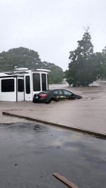
I just got an E solicitation to donate. There are so many scams out there one wonders. You're in the local hood, where would you suggest funds be sent? You might make that a seperate thread.I posted some images earlier and wil post some more from our drive around yesterday. I’m in the local Ham club here, and monitoring the effort. Pretty sudden, and caught many inside their campers along the river’s edge. 14 Rv’s washed away in one park alone. The first two Images are after and before, same spot.The entire park was all assembled for a huge concert and fireworks show. The Entire park venue was scrubbed by the waters, not a single fixture remaining, and the stage was pushed and mangled downstream into the trees. Some cypresses were de-barked as much as 15 ft above current level of water at the time we took the photos, so it had gone down already by 0930.
Our radio Shack is pretty close to the river, so we didn’t staff it during the high water period, as egress from the area, is iffy. Google maps, on satellite view gives you an idea of where things are. Flat Rock. Park was totally under water, all of the lower part of. Shriner Park was covered, The hwy 16 bridge which is about 50 ft, high, had water up to 4 ft from the bridge bottom. Fernando Lemos bridge was under water, and the veteran Loop bridge was about 4 ft from the water. The concert stage was. Crumpled like a beer can, and pushed into the trees downstream.
And the kids? Unknown. Campers? Unknown. Entire families suddenly gone. People in cars who tried to escape, trapped and screaming as they floated downstream. The kid in the tree, went over 15 miles, and tumbled over 5 dams.The hydraulics at the dams were like a rock tumbler, churning logs and tires, and debris over and over.
I just got an E solicitation to donate. There are so many scams out there one wonders. You're in the local hood, where would you suggest funds be sent? You might make that a seperate thread.
lawyer #1: man, i'd like to fuck her!I can hear the lawyers schemeing now..."Who can we sue?"
The camp will get it first, failure to notify of impending danger.
Then anyone else they can think of.
lawyer #2: out of what?
I'm going to burn in hell.Jew #1: man, i'd like to fuck her!
Jew #2: out of what?
so they were seeding, but had stopped on july 2nd.I actually thought this. I would NOT doubt it was a seeding in the mix.
Rainmaker CEO To Speak Publicly Amid Cloud Seeding Scrutiny Over Texas Floods
Rainmaker’s CEO will take public questions in a live X Space after seeding clouds just two days before Texas’ deadly July 4 floods.
 dallasexpress.com
My dad lives on the Guadalupe. Well, he lives in the Guadalupe drainage. His house is more than a mile from the river bed, but I’ve seen flood water in the back part of his pasture, and caught gar out of a stock tank, that were left in it by river floods. But, this is in South Texas, well below Canyon lake. By the way, there’s a reason that canyon lake is called canyon lake. Anyway, Kerrville is basically in a desert. This amount of rainfall in this area is almost unprecedented.I can tell you that 30 yrs ago, I worked in regional air quality planning and therefore had to know about the types of computer models used in atmospheric/tropospheric/stratospheric analysis, including Wx modeling that existed at the time. Already 30 yrs ago it was ultra-expensive and not very accurate when compared to reality.
But historical data on rivers that are either critical for drinking water/agriculture, or critical to watch for flood events, that exists as well and you can talk to folks in geology and hydrology about watershed historical data, flood events, rapidity of floods, etc.
The ability to "predict" the exact cfm flows from a storm, of course not possible.
The ability to see trends over history and know where floodplains are, and how fast a flood has happened, for the river in question? It's not in the middle of the Alaskan tundra 100+ miles from hints of civilization.
My point is, instead of relying on brittle space-beamed imagery alone, they have hydrologic history for the river and for pete's sake you can see rain falling when it falls and aircraft can relate what they are seeing, cloud formation / storm wise. What kind of "emergency response" does not account for space-beamed imagery going down? What the hell is that?
The meeting was in January, where does it say "2 days before"? Not disagreeing, just don't see any verification.I actually thought this. I would NOT doubt it was a seeding in the mix.
ETA: LBC cleared it up
Salvation Army or your church. Avoid go fund me’sI just got an E solicitation to donate. There are so many scams out there one wonders. You're in the local hood, where would you suggest funds be sent? You might make that a seperate thread.
debonked or are they doing it?
So Saturday geophysicist Stephan Burns (solar flare/schaumann resonance guy) did an hour video on why he thought this was likely, because of the sheer volume and the fact the deluge was so concentrated and didn't move like typical storms.
Shawn Ryan actually had the CEO of Rainmaker Technology on 3 weeks ago, the company involved in the above contract, who specializes in cloud seeding with silver iodide. Would be interesting to see in rain water/soil reflect amounts of sodium iodide above baseline.
Last edited:
They need cloud seeding Canyon lake is at an all time low, the rivers are low. Cloud seeding also doesn’t change weather patterns it “redistributes existing moisture” in individual clouds. it’s not what people imagine it just pushes existing moisture in the air to condensate. If the air is dry you aren’t going to make it any wetter with cloud seeding.So Saturday geophysicist Stephan Burn (solar flare/schaumann resonance guy) did an hour video on why he thought this was likely, because of the sheer volume and the fact the deluge was so concentrated and didn't move like typical storms.
Shawn Ryan actually had the CEO of Rainmaster Technology on 3 weeks ago, the company involved in the above contract, who specializes is cloud seeding with silver iodide. Would be interesting to see in rain water/soil reflect amounts of sodium iodide above baseline.
Here's the best explanation I've seen for how the conditions developed to bring about this disaster -
It can't be emphasized enough that this occurred in the early morning hours when most people were asleep.
Nope, got to be a conspiracy theory. The dry/packed/rocky/sloping ground getting almost an average years rain fall for the area in hours do to a stationary storm being fed moisture from remnants of a tropical storm that just so happened to be moving that direction definitely has nothing to do with it.
I’ve seen people saying it was caused by a dam being opened 2 hours away DOWN STREAM.
It’s pretty much the same situation as western NC, way higher than normal rainfall in an area do to already having weather and larger tropical systems adding to it, it’s funneled to narrow valleys(river bed) where people decided it was a good idea to build in the worst spot in for these situations, and It’s not the first time there’s been flooding in either area. The Guadalupe floods about once a decade like clockwork
Last edited:
Check with Samaritan's Purse alsoSalvation Army or your church. Avoid go fund me’s
Similar threads
- Replies
- 2
- Views
- 2K
- Replies
- 100
- Views
- 16K
- Replies
- 3
- Views
- 4K
