Range Report Why density altitude..?

dareposte

Sergeant
Full Member
Minuteman
Mar 4, 2010
451
0
114
Grand Rapids, MI
www.dop3.com
So I've been seeing a lot of buzz about density altitude and shooting, but am not sure I understand why it's more useful than station pressure and temperature.

Anybody fill me in? DA was originally made for aircraft test comparisons, and I see how it can be accurate but it seems needlessly more complex... Very abstract for an already difficult to grasp subject.

 
Re: Why density altitude..?

Someone like Lindy or Lowlight can probably explain it much better than I can, however I like using DA because it combines several environmental factors into one figure. To me that figure is much easier to keep track of and use in a variety of conditions whether I'm shooting in the mountains of West Virginia or down in North Carolina. Calculating and using DA is also a lot easier than you think, especially with available products and resources like Kestrels, FDAC's, JBM, and the numerous other ballistic programs.
 
Re: Why density altitude..?

It's actually much easier to use 1 number than to use all that goes into Density Altitude.

D/A combines Barometric Pressure, Temperature and Humidity into one number than can give the shooter something to use that the bullet thinks it is flying at.

I would start here, page one and look at the simple solution for the FDAC or Field Density Altitude Compensator. http://www.snipershide.com/forum/ubbthreads.php?ubb=showflat&Number=2400424&page=1

Then you can look to other sources, but a lot of people are using D/ A to great effect, why because that is where the bullet believes it is.

For example, at Rifles Only in South Texas, they are at 78ft above sea level, however the D/A for that area hovers around 1500ft because the temperature is hot and the bullet believes it is flying in air that is less dense. In the summer it goes over 2500ft in the winter this year we saw it go below -2500ft, in all in a one week period we say a 5000ft change in D/A which is important because that is what is telling the bullet how well it can fly.

Now, picture a Special Operations sniper, using something like FDAC or not, but understand most of these guys get to where they are going thanks to Helicopters and their air crews... these guy use D/A to tell the pilot how much weight they carry, so they know the D/A... need a number ask the air crew. But most carry Kestrels... however instead of needing a ballistic computer to compute the same thing, you can use the D/A and approximate it thanks to your Databook or cards.

Lindy has more details, this is simplified answered... but D/A is good 1 number to help understand what the bullet is doing.

Here Lindy has an explanation on how to make D/A cards for yourself.

http://www.arcanamavens.com/LBSFiles/Shooting/Downloads/DA/

It's more than buzz.
 
Re: Why density altitude..?

<div class="ubbcode-block"><div class="ubbcode-header">Originally Posted By: dareposte</div><div class="ubbcode-body"> DA was originally made for aircraft test comparisons, </div></div>


B/c bullets don't have turbo chargers to standardize their flight conditions under changing circumstances; therefore the only option is to understand and factor in the environmentals prior to projectile departure.


Good luck
 
Re: Why density altitude..?

Thanks for all the feedback. I think it makes sense in the field if you have a Kestrel that does it all for you since there are fewer ways to make an error on the data input to the ballistic calculators.

I understand exactly what DA is and agree that it's a valid way to model atmospheric effects on bullet flight, my curiosity mostly is as to why shooters are adapting it. It's no more valid or accurate than the traditional pressure/temperature/humidity combination, and is more abstract and difficult to understand and explain.

Reading between the lines it sounds like the answer is "Because my Kestrel does all the math and it's easier to use the single variable than the three separate ones, and its just as accurate with less opportunity for error." To Lowlight's point, it would also simplify the stack of range cards combinations when not using a computer - that's something I hadn't thought about. Having a stack of range cards with DA at the top makes a lot of sense. That's good enough for me, I think I'm on board with the concept now.

I'm just a recreational shooter, so a sighter or two is not a big deal to me, and for the most part I neglect humidity and just use temperature and station pressure for long range. If I am going to the local range on a "normal" day I'll sometimes neglect station pressure and just pick the closest range card to the temperature I think it is, and be on target no problem using 29.53 in-Hg ASMC pressure. Mostly that simplifies my stack of range cards to temperature @ std pressure. But using DA, I could do the same thing and just pick the closest DA to "Average" and probably have better results.

I guess you still have to correct for temperature variations on MV separately right? My range cards have that built in the way they are now for my standard loads, which I would lose by using DA since a DA does not define a temerature.

 
Re: Why density altitude..?

In a nutshell, your density altitude tells you how high the air around you would have been if it were a "standard" day. If DA is higher than your actual elevation, the air is thinner than a "standard day." If it's lower, the air is thicker.
 
Re: Why density altitude..?

If you look at the databook pages done for Rifles Only and myself from Impact or Storm we actually remove "humidity" as an input field and replace it with D/A.

It doesn't get any easier or more accurate that using something like the FDAC. You just insert the appropriate card that is based on your MV and off you go. It requires nothing more than knowing your altitude and temperature to figure out your D/A then slide the card to the area of the drop table you need. If you don't want to use electronics like a ballistic calculator & a Kestrel it's definitely the way to go. The cards let you figure it and I can get everything I need from my watch and nothing more.

If you have a ballistic calculator and kestrel I recommending using the individual values, the PDA is doing the work for you so it doesn't really make a difference. But if you don't D/A is faster and easier. Both in a logbook and out.
 
Re: Why density altitude..?

<div class="ubbcode-block"><div class="ubbcode-header">Originally Posted By: vman</div><div class="ubbcode-body">Can you get customized cards for the FDAC? </div></div>

We have a totally new product line that is very near release that is completely customizable and extremely inexpensive. Stay tuned, it's coming.

Taylor
ACTS, LLC
 
Re: Why density altitude..?

Thanks Taylor.

Looking forward to its release. Would like to have other cards besides the 175smk calibrated.

I dont currently own an FDAC as I use Kestrel/Ballistic Calc combo, but is it worth waiting for the new release or can existing customers benefit also?

Looking to add one to the Data Book and MilDot Master
smile.gif
 
Re: Why density altitude..?

Lowlight - Thanks for cluing me in on the benefits. I've been messing around with the density altitude and it really does simplify things greatly.

Now instead of tracking all the variables and swagging a guess at the best card to use, I can just pull a METAR report before I go out and bring that density altitude range card and maybe one for a slightly warmer temperature for my shooting trip. Pretty sweet deal and much easier to keep track of it all.

I'm a fan of the paper-only approach you can use for density-altitude, so I printed out an 8.5x11 with the density altitude chart with a pressure-altitude reference on it, and on the back side 6 range cards for -2000 to 5000 feet of density altitude. With my watch (reads temperature and station pressure) I can be almost on the money with nothing more than one sheet of paper.

I like it so much, I updated my dop3.com ballistics computer to use density altitude too.
 
Re: Why density altitude..?

<div class="ubbcode-block"><div class="ubbcode-header">Originally Posted By: Lowlight</div><div class="ubbcode-body">.....It requires nothing more than knowing your altitude and temperature to figure out your D/A then slide the card to the area of the drop table you need. </div></div>

That altitude input must be pressure altitude and not field elevation unless, depending on current conditions, are the same.
 
Re: Why density altitude..?

No the altitudes listed on the FDAC's estimation chart are for your physical altitude and air temperature, if you have an idea for those you are good to go.

For example the current weather stats here in Winchester are

41* F
44% humidity
Just under 1000' elevation (700' on average)
30.18 inHg.

Plug that into this DA calulator and you'll get about -500' DA.

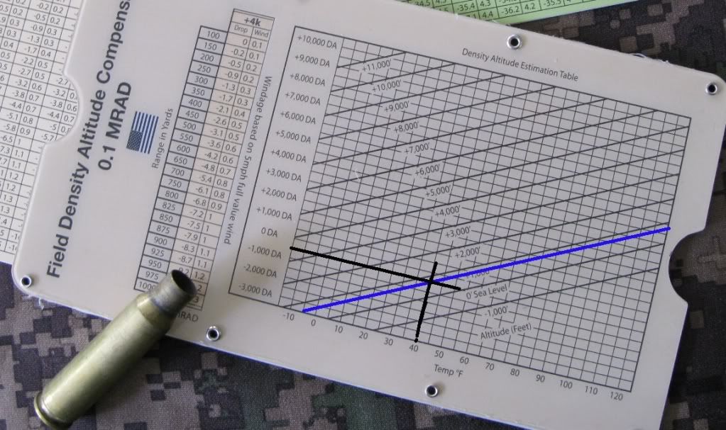
Using the FDAC's chart and knowing that I'm at around 1000' of elevation with a temp about 40* F I came up with -500' DA.

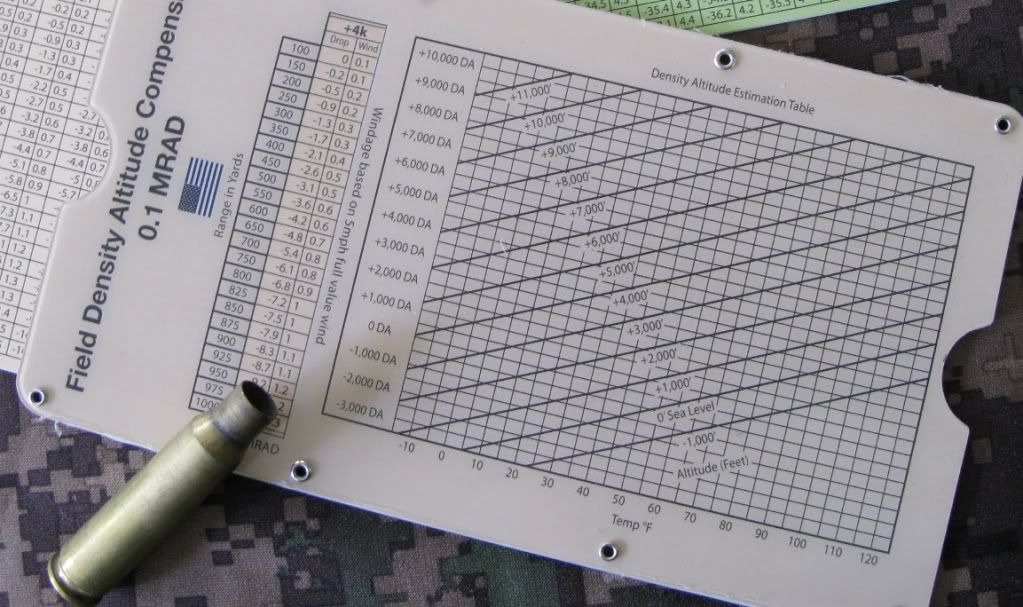
Here's a pic of the FDAC's chart so you can see I'm not fibbing:
Go to the 40* line, go straight up to the intersection <span style="font-weight: bold">just below </span>the +1000'(700') solid line and trace over to -500' DA.
FDACchart-1.jpg

FDACchartII.jpg


I don't know what all Adaptive did to make it work but it works very well and has been no more than 2/10's out from my actual dope so far.

 
Re: Why density altitude..?

<div class="ubbcode-block"><div class="ubbcode-header">Originally Posted By: Trigger Monkey</div><div class="ubbcode-body">No the altitudes listed on the FDAC's estimation chart are for your physical altitude and air temperature, if you have an idea for those you are good to go.

For example the current weather stats here in Winchester are

41* F
44% humidity
Just under 1000' elevation (700' on average)
30.18 inHg.

Plug that into this DA calulator and you'll get about -500' DA.

Using the FDAC's chart and knowing that I'm at around 1000' of elevation with a temp about 40* F I came up with -500' DA.

Here's a pic of the FDAC's chart so you can see I'm not fibbing:
Go to the 40* line, go straight up to the intersection just below the +1000' solid line and trace over to -500' DA.
I don't know what all Adaptive did to make it work but it works very well and has been no more than 2/10's out from my actual dope so far.

</div></div>

Sorry... density altitude is computed from pressure altitude, not field elevation. Do you know how to compute pressure altitude?

You should look closer at your example. At 41 degrees and 1000', you are closer to 0 ft DA. 35 degrees would be closer to what you quote, according to the chart. The flaws in this program will exaggerate as altitude increases.

I was a commercial pilot for over 30 years I know about these things. You will not get density altitude using field elevation unless the conditions are standard ICAO.
 
Re: Why density altitude..?

Well shooting a rifle is not flying a commercial airplane loaded to maximum weight so you can get away with some thing not being exact.

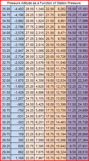
you can use Lindy's Link to calculate the "Pressure Altitude" however for the purpose of shooting and as far as the bullet is concerned, you have no need to be "that accurate"

Manually Calculating Density Altitude
pasheet.jpg


I mean, let's look at ranging for instance, the standard is +/- 5% of the range, which is more error than using the D/A as the table suggests.

There are times when the user will have no access to measurement equipment so under field conditions, which is what this is for, not scientific purposes or flying a plane under load, this gets you close enough for government work.

But Leaddog is simply trying to prove he is smarter than everyone else cause he shoots F Class. In the field you can get away with over 500 ft of D/A swings in some cases even more.
 
Re: Why density altitude..?

<div class="ubbcode-block"><div class="ubbcode-header">Originally Posted By: Lowlight</div><div class="ubbcode-body"> But Leaddog is simply trying to prove he is smarter than everyone else cause he shoots F Class. </div></div>

Hey Frank... why be a smart ass? Go ahead and use your FE calculations at high altitude and see how far you miss your target.
 
Re: Why density altitude..?

<div class="ubbcode-block"><div class="ubbcode-header">Originally Posted By: Leaddog</div><div class="ubbcode-body"><div class="ubbcode-block"><div class="ubbcode-header">Originally Posted By: Lowlight</div><div class="ubbcode-body"> But Leaddog is simply trying to prove he is smarter than everyone else cause he shoots F Class. </div></div>

Hey Frank... why be a smart ass? Go ahead and use your FE calculations at high altitude and see how far you miss your target.</div></div>

If I am at "high altitude" I have other things to worry about, like breathing under heavy load... Besides I live in CO and I haven't had an issue yet with it. Is that high enough, I am only an hour from 14k if you want me to try that.

We all miss our targets, how we correct it is what separates one shooter from another... missing just means I am shooting and pushing myself, maybe if I hung out on a KD course more I would learn to never miss.

As far as being a smart ass, I was answering you in the tone in which you posted, and I feel you deserve to be answered.
 
Re: Why density altitude..?

This chart is not made for a pilot or an F-Class shooter. It is made for a young, basically trained military sniper operating in austere conditions that may compromise many battery powered weather gizmo's. Try throwing a 60-70 pound pack full of comm gear, water, food, and other equipment out the back of a truck in a big hurry. Often, you'll find your cool, ultra accurate weather instrument in pieces when you need it most. <span style="text-decoration: underline">"When you need it most"</span> is not when you're on the 1,000 yard line at Camp Perry, its when you're young, you have a family half a world away that loves you, and your shots will help other young people maneuver closer to an enemy - so that those enemies can be shot in their faces, stabbed, or beaten to death.

Grunts (Infantrymen) carry maps. Often, not everyone has one, and they are sometimes referred to as "The Map", and commonly used in phrases such as "let me see the fuckin' map". Maps have elevation and contour intervals printed on them. Explaining Pressure Altitude to the masses of young people that use the product, that have 19 other things to do other than simply shooting is a recipe for confusion and the introduction of conjecture. Yes using Pressure Altitude is preferred, but a bit harder to apply to all users of all experience and ability levels. This is not a <span style="text-decoration: underline">guess</span> or an <span style="text-decoration: underline">assumption</span> of mine.

This tool is designed for speed, simplicity, and ease of use under stress and mental fatigue.

Worry not, I shoot F-Class too, I like it, i'm a fan, but I also completely understand both modes of thinking. But who knows, maybe I'm wrong, It's good to be wrong sometimes.
 
Re: Why density altitude..?

I've seen where this can have tragic consequences because of mix-ups.

The old Irvin FF-2 HALO Parachutist's Automatic Ripcord Release was routinely set using "Uncorrected barometric pressure" vice the drop zone or field "Altimeter setting" corrected for the height above sea level and temperature.

The jumpmaster (a good friend and one hell of a talented guy -- he taught my HALO Jumpmaster Course) called the far-end field (instead of the hospital) for an "Uncorrected barometric pressure" (I guess used for anesthesiologists and respiratory data) and got the "Altimeter setting" (a common aviator term) from either the tower or flight service center. Go to the whiz wheel and do your gonculations. Set the automatic openers with the wrong data and the machine is set to open a disabled parachutist's gear -- 1500 feet below actual ground level (flying from Fort Bragg to Colorado at night).

Got to have everyone on the same sheet of music. In training it's a blown shot. At 10 - 12,000 feet running a ridgleline it's a miss.

I love the concept of paperless first-round hits without batteries. I love gadgets that fit in the pocket that I can use without worrying about losing a charge or an LCD screen freezing and going black.
 
Re: Why density altitude..?

<div class="ubbcode-block"><div class="ubbcode-header">Originally Posted By: sosicmcise</div><div class="ubbcode-body">I applaud the use of the term "Goncluations". Outstanding!

Urban Dictionary "Gonculations"
</div></div>

The sophisticated term for SWAG.

I always use a Kestrel for my DA but I also refernce it with what I would get by my DA chart if the Kestrel died and I used my thermometer and elevation. They correlate pretty good...good enough that I am not worried about "what if my Kestrel dies" at an inopertune time. I love the DA based solutions to dope....they make things so much easier and faster.
 
Re: Why density altitude..?

Anyone know any other non-electric / non-battery analog field ballistic aides out there besides these? Surely folks aren't taking their i-Phones with all their personal data in them into combat?

FDAC cards

DSC_0016.JPG

DSC_0019.JPG


Accuracy 1st Whiz Wheel

whizWheel2.png


Tactical Adjustment System (TAS)

BWtechbasic.jpg


I think I can carry all three and save the space my abacus and counting stones take up now.
laugh.gif