• Watch Out for Scammers!

    We've now added a color code for all accounts. Orange accounts are new members, Blue are full members, and Green are Supporters. If you get a message about a sale from an orange account, make sure you pay attention before sending any money!

Density Altitude Help Please

SoldierofFortune1

Private
Minuteman
Oct 2, 2007
42
1
48
I want to make me as a Backup a Field Density Altitude Card.Now i am going crazy cause i dont know how to do this correct?
My Problem is to put the correct Altitudes in JBM!
I visit the Homepage from Skillatarms.

Example:

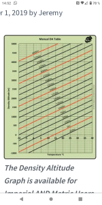
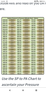
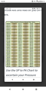
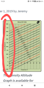
I use this two charts from skillatarms(Station Pressure to Pressure Altitude and the DA Chart).
Now i figure out what ma DA is.
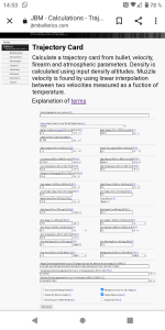
Next Step is,i went to JBM and fill out all my variables like MV,Sight high etc.
They say my Temperature Input is only to calculate MV.
Temperature doesnt interest cause its in the DA Factor.

And now my Questions:
1.What Altitudes do i set?My local Altitudes where i am Shooting(but this makes no Sense,cause than it is a normal Trajectory Table ,right?),or the DA Altitudes what i want to have?(like -1000,-500,0,500 from my Skillatarms chart )?

2.And if i do DA Altitudes in,why is on the Trajectory Card a Temperature shown?I think it is in the DA Factor included?

I hope you guys know what i mean and can help.Or can someone explain it detailed how i have to do it correct?

Thanks,Marco
 

Attachments

  • Screenshot_20211118-145211.png
    Screenshot_20211118-145211.png
    750.5 KB · Views: 86
  • Screenshot_20211118-145224.png
    Screenshot_20211118-145224.png
    879 KB · Views: 83
  • Screenshot_20211118-145324.png
    Screenshot_20211118-145324.png
    199.7 KB · Views: 81
There are several ways to do this, basing of what I understood. You can use several DA calculators. Find one and input the necessary data.

Look up General areas of where you will be shooting for Altitude, temp, humidity, baro pressure and use that data. It will give you a general number.

Or buy a Kestrel with AB and you're good to go
 
Thank you for answering.
My english is Not the best and Maybe i have to ask otherwise?
At the Homepage from skillatarms Jeremy say you Need a watch or a Kestrel to know Station Pressure and Temperature.So far i understand.
Second step is to estimatet(from the Chart) your Station Pressure to Pressure Altitude.
Now i have my Pressure Altitude.
Then i Went to the DA Chart and Take my Temp. Go above to the estimated Pressure Altitude,then left and i have my DA in Meters.

Now i Need the ballistic Tablet for my come Up and windage.

To built that Table i use JBM.
And when i am done,my Rangecard shows Altitude(IS IT over sea Level or the estimated DA Factor Altitude),Temp,Range.

Why the Table Shows Temperature at this Output when Temp.is Inside DA?
Does anyone have a printed DA Card for lets say M118 LR Ball that i can See and Check the Difference to my Card?

I use a weatherflow weathermeter,and want to have IT only as Backup,my my brain going crazy with this Altitude Input!
On that particular page, you enter up to ten Density Altitudes you want comma separated. The pre-populated values are 1000,4000,7000.

The clue on this page is it doesn't ask for pressure anywhere which is needed to calculate DA.
 
Dont overthink DA. Its not complex and for our purposes you do not have to be exact, rounded to the nearest 1000 is more than adequate, nearst 500 if you have OCD.

DA is simply standard pressure corrected for non standard temperature. what im about to tell you will get you to within 300 feet of actual DA in seconds. you just have to remember a few key things. Also, this method doesn't account for the affects of pressure or humidity which is why its within roughly 300 feet of actual DA. If you want to be that exact, ill try and find a cheat for you.

first off, there are two thing used when it comes to atmosphere. We have standard pressures and standard temperatures at every altitude. NExt, the standard lapse rate is 1" of Hg per 1000 foot increase in elevation and 3.5 degrees F (2 degrees C) per 1000 feet. what does that mean?

Example 1 (Standard Atmosphere):

29.92" Hg at Sea Level and 59 degrees F (15 C) 0% RH this is is the equivalent of 0 DA. if the temperature was 74 degrees, DA would be 1000'.

TIP: DA increases 1000' for every 15 degrees F increase above standard (or below for that matter......yes negative DA is possible).

so knowing what i just told you above you can get real damn close to actual DA if all you know is your approximate elevation and the temp.

Another example:

Example 2:
Elevation 3422
Temp 73

Standard pressure at 3000' is 26.92 (29.92" - 3.00") and standard temp is 48 (59-(3.5*3)=10.5 rounded up to 11)

since it is 73 degrees and standard temp is 48, we are 25 degrees above standard. since we know DA goes up 1000 for every 15 degrees above standard, we know that we are at 1.67 times (25/15) the elevation. 3000*1.67 = 5010. DA is approximately 5000.

Does any of that make sense?
 
  • Like
Reactions: Northman623
Ignore all that bullshit above. I get it now and what JBM is feeding you. its calculating DA but not telling you what DA is. In these two windows

1637252826678.png


put temp at every 15 degrees starting at 0 (0, 15, 30, 45, 60, 75, 90, 105) and altitude at every 1000 (0, 1000, 2000, etc)

1637252989077.png


It doesnt tell you what the DA is, but its giving you the drops it (you can note the DA by using the method above)


1637252974437.png


You can use this to put notes at the very top of the table

1637253242449.png
 
Thank you Sir for your time and Work spendi g to Help me.
Okay now WE CAME a little Bit closer.
I use metric Units but this doesnt Matter.
Lets say i Put in 0/15/20/25/30 Celsius,
and (now the importamt Thing) Set Altitude at 0/500/1000/1500/2000/2500 Meters(does ist means 0/500/1000/1500/2000/2500 Meters above sea Level?
And If yes, i dont know how i Work with the DW Table from skillatarms?Or IS this Impossible cause JBM doesnt Shows DA?
I Hope you know what i mean?
On that page to create Trajectory cards, YOU are entering the desired DA's you want to have drops for.
 
Okay than i can Work with skillatarms Table and JBM DA Table together,right?

Lets say,i know my Pressure Altitude and Temperature and estimatet my DA from the DA Card.
Then i Go Go my Trajectory Card from JBM,and Take the Same Altitude what i am entered in,and this Matches together?
 
Yes, same density altitude (or closest one you created a chart for).
 
Okay than i can Work with skillatarms Table and JBM DA Table together,right?

Lets say,i know my Pressure Altitude and Temperature and estimatet my DA from the DA Card.
Then i Go Go my Trajectory Card from JBM,and Take the Same Altitude what i am entered in,and this Matches together?
before i respond further, what do you mean when you say pressure altitude?
 
Station Pressure Convert to Pressure Altitude in the Table.
 

Attachments

  • Screenshot_20211118-180934.png
    Screenshot_20211118-180934.png
    676.4 KB · Views: 70
When you Swatch at Google for Density Altitude Chart you come to skillatarms.
Pleased read this what Jeremy weites how to use this Tables.Description.
Maybe than you know what i think about?!
 
I use a weatherflow weathermeter.
I know the ICAO Table and what that means for calculating the DA,but i cant get This Charts from skillatarms and a Trajectory together in use.
What i mean is,If i follow the instructions from Jeremy from skillatarms with the DA Table,and read the DA(Pressure Altitude and Temperature:DA).and Look to my Trajectory Card from JBM what i was built with entering at the Altitude Numbers -1000,-500,0,etc .and read my Trajectory,does this Match together Like 6.5 SH Said?
IS IT that simple?
 
Okay i try it least.

Is the DA Number from the Green Chart(Estimatet from Temperature and Pressure Altitude),the Same DA Altitude what i enter in JBM Altitude ???
 

Attachments

  • Screenshot_20211118-192936~2.png
    Screenshot_20211118-192936~2.png
    678.9 KB · Views: 61
  • Screenshot_20211118-192820~2.png
    Screenshot_20211118-192820~2.png
    866.1 KB · Views: 66
Okay i try it least.

Is the DA Number from the Green Chart(Estimatet from Temperature and Pressure Altitude),the Same DA Altitude what i enter in JBM Altitude ???
Correct, make your charts with the expected DA's for the places/times where you shoot.
 
Correct, make your charts with the expected DA's for the places/times where you shoot.
Yes that chart uses the DA and temp for muzzle velocity calculations. make sure this area is accurate

1637264313382.png


as for using that chart from that one guy, yeah you can do that or you can use the shortcut i provided earlier to get really damn close when in the field. Now i will say this, while DA charts are very useful as hasty field cards, no two DA's are equal. 3000 ft DA can be had in many different ways and its much better to use Temp, pressure and RH to get the actual ballistics than just using DA. but, having 1 card is much easier than having many. i get it.

this DA chart, IMHO, is much better than the one from that website which is found in every aircraft manual ever. its a good chart, this is much easier. know your elevation and temp and boom.

1637264616797.png
 
  • Like
Reactions: Holliday
All right.
This Table IS pretty cool(thumbs Up).

1.Is IT possible to Change Fahrenheit and feet into Metric Units?I Like IT Bit more.

2.How do you use this Table in a real world scenario on the Range with a Ballistic Chart?
Can you Post a Picture from a Rangecard what you use in conjunction with the DA Table?

Example:
You know your Temp and your Altitude about Sea Level.This will give you the DA Number from your DA Chart.(lets say 1878).

Now you Change to your ballisticcard/Rangecard etc...and Search for the nearest lets say 2000.Here are the Dopes for come Up and Wind.
But why are at the ballisticcard at 2000 different Temperatures listed?Cause in the DA Number is Temp.included?
In my brain i think i only Need my Range to the Target and the DA Number?Or IS IT simple that different Temperatures give different come ups in the DA Number?

Thanks for answering all my dumb Questions?
Maybe i think to difficult about that Thing,but i want to learn to solve this Thing.
Temp is accounted for in DA. In that JBM trajectory, temp is used to calculate velocity changes. Temp goes up velocity goes up and vice versa. You have to give it a baseline MV then a high and low temp and associated MV and it will calculate the change in MV in fps per degree up or down. Then that will be applied to your trajectory

if you want that chart in metric, just do the conversions and rebuild it. I don’t have a meters or C because we use Freedomheit and feet here in Merica.
 
May,many thanks Guys.You are the Best.
I will Change the DA Table in Metric Units und make my Card at JBM.
Regards,Marco
 
I didn't read all the responses but Temp is still an extra variable in Ballistics programs even though it is also included in DA because we model air as an ideal gas.

In an ideal gas the speed of sound is dependent solely on temperature and since these programs reference a table of drag coefficient vs Mach number it needs that temperature to be set as well as the DA.

Some programs will also calculate your muzzle velocity change based on temperature if you give it enough information.

If I am making DA cards I usually select a temperature that is in the middle of my expected temp range and roll with it.

Hope this helped. It had me confused for a while as it seems like it is a redundant input if you are using DA.
 
Special thanks to Tacticaldillhole.
After Reading all twice what you say and explain for me,is now a Big bright light growing Up in my brain:).
I think to complicated from Start Up.

This was the explaining what i Need to Check this DA Thing.


Dont overthink DA. Its not complex and for our purposes you do not have to be exact, rounded to the nearest 1000 is more than adequate, nearst 500 if you have OCD.

DA is simply standard pressure corrected for non standard temperature. what im about to tell you will get you to within 300 feet of actual DA in seconds. you just have to remember a few key things. Also, this method doesn't account for the affects of pressure or humidity which is why its within roughly 300 feet of actual DA. If you want to be that exact, ill try and find a cheat for you.
 
Yea
What dill hole said is GTG
Don’t overthink it.

If I don’t have access to weather I find the elevation and use it with a modifier.

Example-one of my spots is 2400ft of elevation
On a cold day I’ll use 1400, moderate day 2400 and warm day 3400.
That always gets me quite close.

Back when I ran charts I had them in 1000 foot increments.
 
Margin of Error in Minutes of Angle (MEMA)
I was curious about the true effects of varying environmentals....so I spent an hour with my lovely Kestrel and came up with this: inside 800yds it doesn't matter much, inside 600yd it really dont matter (majority of PRS shots are 6-800yd FROM WHAT I KNOW).

Zero and gather solid data at an average (middle of the road) DA (70deg/2kft), and when its 70+ and/or >2k DA you subtract .1mil (maybe 2 clicks at 800yd), when its less than 70 and/or <2k DA add .1mil (maybe 2 clicks at 800yd) to your "normalized DOPE" and send it!

Unless you are trying to hit quarters with your premo handloads at 6-800yd (which you'd prolly be in prone anyway at that point), you will most likely have accurate enough data to hit PRS style targets by using the add/subtract a click (maybe 2 for extremes at 800yd) from your normalized-DOPE (n-DOPE).

*I have NOT actually shot every one of these temp/DA combos in attached file, most are from my Kestrel/AB software but I did true my Kestrel first in a couple different temps and DA's (so the data is pretty accurate for my gun, but not absolutely true 'data on previous engagements' in all cases) but the pattern seems to hold true pretty well. Try it out and lmk I guess!

(see attached file)
 

Attachments

  • MEMA - Looking Cool.pdf
    1.9 MB · Views: 56