• Watch Out for Scammers!

    We've now added a color code for all accounts. Orange accounts are new members, Blue are full members, and Green are Supporters. If you get a message about a sale from an orange account, make sure you pay attention before sending any money!

Mark a straight line in the woods?

Slowbalt

Private
Minuteman
Jul 4, 2021
19
6
Eastern Canada
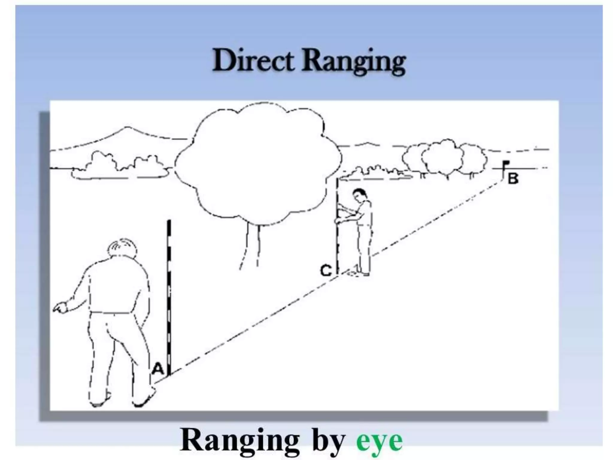
What foolproof way is there to mark a really straight line though woods/brush?

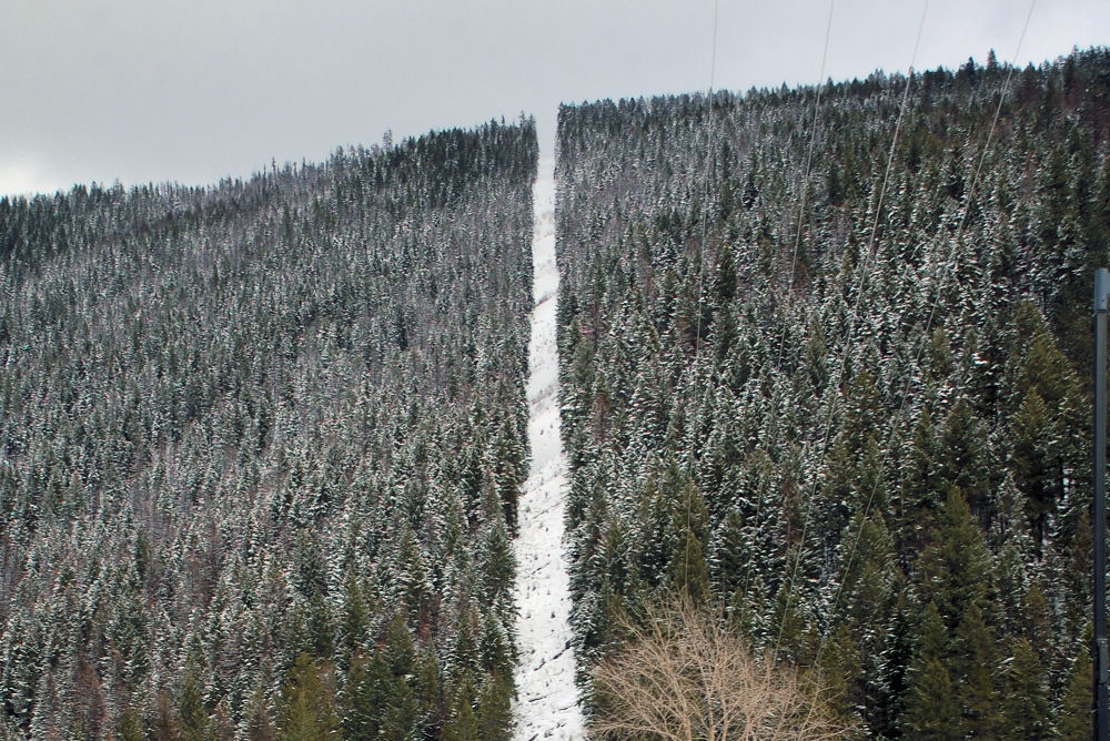
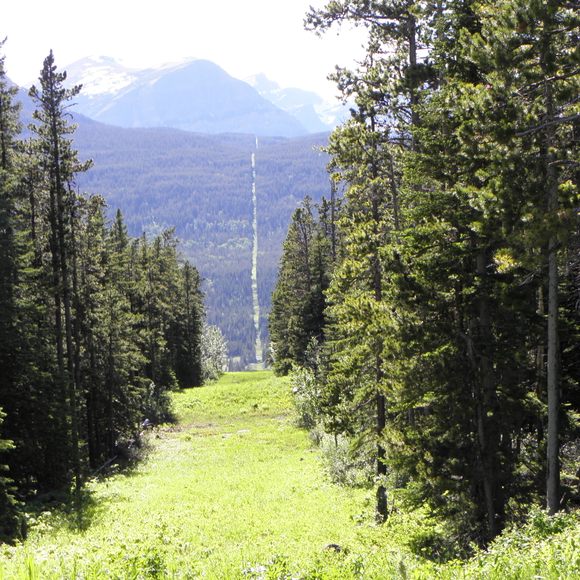
I'd like to make myself a smallish range at camp. I have a nice hill to act as a backstop, and the porch as a firing point. I want to connect the two, but there is nothing but thick brush and woods in between. I'd like to clear about 900 feet long and 10 feet wide.
 
Posting only to see any interesting answers. I have chainsawed my share of crooked, off target lines before, and I would be interested in hearing ideas.
 
If you run a compass while sitting on several tons of metal, your heading will be inaccurate.

Use GPS and a mapping app that let's you draw a line and follow it.

I recommend CIVTAK. I think it's free.
I just checked this out and think this will work well for that purpose. For iPhones it’s called iTak.

Thanks for the info.

FWIW I am not the OP but have a similar problem to address.
 
  • Like
Reactions: camocorvette
If you run a compass while sitting on several tons of metal, your heading will be inaccurate.

Use GPS and a mapping app that let's you draw a line and follow it.

I recommend CIVTAK. I think it's free.
Agree with this. I use Field Area Measure app. Draw your line using the app, walk the line with GPS on in real life, use marking paint to mark the line you want to cut. Then come back with equipment and cut your lane. I have used this many times for shooting lanes, fence lines and key line plowing.
 
You could remove foliage to make a path and use a laser.

Most things, even GPS, will have a margin of error. A tolerance. Lasers are no exception. It’s the same concept as the strong line. You would have to stop every so often to mark a segment with like a stake, because of the limitations of most lasers range. It would be the same as a string line really..

do you have the property survey to pull measurements from?
 
Yeah, use the mapping software to lay down your start and end points along the azimuth you want, use GPS to set them in the real world. Then clear a rough line between them and for finish work you can use string, laser, compass, etc.

When shooting a straight line for a range in the trees, azimuth is the first step, then work from your end points in and check straightness often.
 
Years ago when I was prospecting, and staking my claim, I had to do exactly this. I found what worked best FOR ME, in what I was doing, was to simply borrow a 'hip chain' from a Forestry worker friend of mine.

There's a fair bit to it, though it is simple. Thing is, you'd be surprised as to what outcome you can/will get out of using one. Research it.
 
Use ranging poles. Mark your start and finish points then stick ‘em in the ground every 15ft or so. If you can stand at one end and look at the other with all the poles lining up - congratulations, you have a straight line. Just make sure all the poles are straight up and down (use a plumb bob).

I do appreciate this may be difficult in thick brush and it may be time consuming to adjust and get it right, but it is a low tech and cheap method.

Edit: Just realized you wanted 900ft not 90. Might want to open up that spacing from every 15ft or it’s gonna take you quite a while! In theory, any spacing will work, as long as you can see all the poles.
 
I need to do this for a property, heavy brush also. Following..
 
  • Like
Reactions: lash
Years ago when I was prospecting, and staking my claim, I had to do exactly this. I found what worked best FOR ME, in what I was doing, was to simply borrow a 'hip chain' from a Forestry worker friend of mine.

There's a fair bit to it, though it is simple. Thing is, you'd be surprised as to what outcome you can/will get out of using one. Research it.
I did as you said and read a little bit on it. A simple and effective way to stake actual measurements while you walk.

Super cool low tech measurement method.
 
OP has heavy brush and trees along with a hill. A transit is a good tool, but I think that technology is the first tool to employ.
IDK... They work in a refinery. It's about as crowded as a forest. They can be rented.
 
OP has heavy brush and trees along with a hill. A transit is a good tool, but I think that technology is the first tool to employ.
The brush is going to have to be removed either way if it’s a shootinng lane. Unless I misunderstood the OP.

You can draw a straight line on a map or satellite and then cut it, or you can cut it and draw a straight line…
 
The brush is going to have to be removed either way if it’s a shootinng lane. Unless I misunderstood the OP.

You can draw a straight line on a map or satellite and then cut it, or you can cut it and draw a straight line…
No kidding. The OP has a situation where he cannot begin to see exactly what direction to start cutting. Plus he doesn’t want to cut Willy Nilly and unnecessarily in the incorrect direction. Not being a surveyor.
 
If you have a bearing you can flag it easily . If so, set a marker at your shooting position and hold your bearing while heading to the target area . On that line while pointing towards target put flagging on a branch . Now you can back sight those two points and project your line, by putting a piece of flagging out while you are on line . Now with 3 points you can't get very far off or you will never be able to see all 3 at the same time . Just keep projecting that line, you can clean it up after as you clear a lane .
 
  • Like
Reactions: lash
Start moving a D9, don’t turn. Zero fucks given.

It’s actually interesting looking at straight as an arrow old canals and roadways built in the Colonial years through impossibly dense forests and brush, and think how they did it with a simple sight and a chain.


large_surveying-gear-web.jpg
 
Tie a string to your 6.5 creedmore bullet. Fire at 45 degree angle. Should be straight line for at least 20 miles.

On serious note. GPS coordinates on a straight line, flag each point. Commence to cutting.
 
OK, maybe not a transit and laser -- but OP may require at least one or two other people if you're going by Mark 1 Mod 0 eyeball and not something as primitive as a compass and chains.

He's got to lay out his line before clearing the first tree or bush if he doesn't have line-of-sight. How do you do this with a phone or GPS?

Lewis and Clark surveyed the west with chains. The photos below are the US-Canadian border. Imagine surveying that with a ball of string and a compass.

ranging-170811123447-3-2048.jpg
r7021e0k.gif
BCCanadaBorder_winter.jpg

o9tt0yrer5191.jpg


Last edited:
OK, maybe not a transit and laser -- but OP may require at least one or two other people if you're going by Mark 1 Mod 0 eyeball and not something as primitive as a compass and chains.

He's got to lay out his line before clearing the first tree or bush if he doesn't have line-of-sight. How do you do this with a phone or GPS?

Lewis and Clark surveyed the west with chains. The photos below are the US-Canadian border. Imagine surveying that with a ball of string and a compass.

ranging-170811123447-3-2048.jpg
r7021e0k.gif
BCCanadaBorder_winter.jpg

o9tt0yrer5191.jpg


The us/Canada border is not ackchyually a straight line.
That is due to spin drift.
😀

IMG_0204.png
 
I’m doing this. I’m primitive though. I used an aerial photo to get a compass bearing, then used that to start. Every so often I’ll leave a tree standing if it’s directly in line where I want to go, and use that line of trees to sight down. Flag them with surveyors tape for visibility. I’m hoping to get 700 yards though, and I’m concerned how much I’ll wander by the time I reach the other end. I’m maybe 300 yards in now, but I quit for the winter. Maybe I’ll try some of the ideas above and start from the other end.

I’m starting as narrow as possible, but want to end up 25 yards or more wide by the time I’m done. I can correct some wandering.
 
There's all kinds of seismic-lines cut, up at the Ranch. And I've walked survey lines in the muskeg of Northern Manitoba. That is definitely some 'interesting' trekking, let me tell ya!

(the survey lines for proposed power-lines and such, are about 3' wide. From horizon to horizon, it seems. No matter the elevation/depression.)

Seismic lines are about 10-12' wide, IIRC. Been a lot of years since I've been up there. (Northern B.C.)
 
  • Like
Reactions: lash and Milf Dots
There's some GPS apps that will get pretty close where you can pin a spot then pin another spot and they will take you to both. I would think that's the easiest way to do it. My plan designer has one that he pays for monthly that will do it I believe.
 
I understand the concept of plotting or pinning two points in a mapping, charting, and geodesy app like goggle Earth or falcon view -- but when it comes time for the OP to actually blaze that trail with axe and chainsaw, how precise can a phone or GPS keep you on a straight-and-narrow line? Is there some kind of azimuth pointer and sight like a compass with something that tells you how far from your straight line you're varying (i.e., five or ten feet left or right of bearing) so you can tape or spray-paint the trees you have to fall and clear?

Not trying to be a Richard-head but 300 yards with five to ten feet either side of center-line track can still potentially be a lot of chopping and hauling for one dude, a small family, or work party.

If he rents a dozer he still has to mark his track.
 
Last edited:
  • Like
Reactions: lash
OK, maybe not a transit and laser -- but OP may require at least one or two other people if you're going by Mark 1 Mod 0 eyeball and not something as primitive as a compass and chains.

He's got to lay out his line before clearing the first tree or bush if he doesn't have line-of-sight. How do you do this with a phone or GPS?

Lewis and Clark surveyed the west with chains. The photos below are the US-Canadian border. Imagine surveying that with a ball of string and a compass.

ranging-170811123447-3-2048.jpg
r7021e0k.gif
BCCanadaBorder_winter.jpg

o9tt0yrer5191.jpg


One of the best posts, ever. The YouTube video alone was priceless. Thank you.
 
I've seen seismic crews cut multi-mile lines using a simple sighting compass (later trued by total station/GPS) and only miss their end mark by a couple of yards. 300yds should be easy if you can get a good bearing from Google Earth/similar.

1301_37075_p1.jpg
 
A wine-o and a couple of bottles of mad dog 20/20 , put the wine at one end and the alky at the other and tell him he can have the wine after he clears the path , your welcome.