No qualms to pay up to $80...still a steal in my bookLooking forward to it. Will go buy $40 in Play gift cards since the release is imminent.
")

Follow along with the video below to see how to install our site as a web app on your home screen.
Note: This feature may not be available in some browsers.
No qualms to pay up to $80...still a steal in my bookLooking forward to it. Will go buy $40 in Play gift cards since the release is imminent.
Just bought it. Worked here. Now time to wait to hear how to use it.Hi,
Android getting closer, lol.
I just tested downloading from the play store.
Come on Google validation department!!
Sincerely,
Theis
View attachment 7606521
Hi,
Guys, lolol....Do NOT purchase it yet....it is still Beta version and Google has not validated it completely yet lol
Sincerely,
Theis
Hi,
Damn Google, lolol...
It is not supposed to be letting anyone not assigned to a specific email group download the app, lololol.
Since Google still list it as "Under Review".
Sincerely,
Theis
Hi,
View attachment 7606625
Android is live!!
New website with video highlights and instructions coming soon.
Sincerely,
Theis
Congratulations Stud!
Nice Job!

As a former beta tester looking forward to the final product!Hi,
Guys I am pulling all the comments/questions/etc and compiling a meeting list agenda for us to go over internally.
I will update each as we get to them to make sure everyone knows and understands what is going on.
Sincerely,
'Theis
Just under one year since that first post, well done @THEIS and team!Hi,
So we finally have the app development team lined out for a new ballistic app system that is a joint venture between Hoplite Arms and Patagonia Ballistics so I would like to here what you all have to say on Range Card Layouts.
What are your desires/request/must have/cannot have/etc etc when it comes to range card layout and features?
Sincerely,
Theis
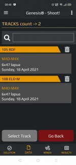
A track is your rifle and cartridge setup. 223rem 68gr on a AR15 is one track, your bolt action 308win W/ 175gr SMK hunting is another track.When I plugged the environmentals in and
I'm new to the coldbore engine, a "track" is a set of conditions, yes?
As a long time CB user make sure your version is 1.0.15.0 there was a previous post about this update. I've installed Genesis yesterday and have to say that the procedure is quite simple and pretty straightforward. There are two Tracks files, one for Genesis and the other one for CB. In CB execute the Open Data Folder command and copy the Genesis file to the Genesis data folder in your phone and you are done. In the System module you can find its location, which is in Internal Storage. Another way is to email yourself the files from CB to Genesis or the other way around and copy the file(s) to the proper location in each program."The user can also share data files with ColdBore© Desktop edition." How would this be done, instructions would be nice. I have bought the app for my phone and have the ColdBore desktop software, not sure how to proceed from a workflow point of view?
Thanks!View attachment 7607503
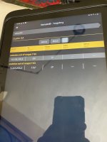
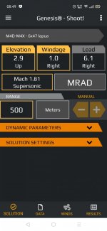
Click the AUTO and you should get MANUAL pop up, then you can click the number and put in any exacting number, up to 4500m.
Hi,I was going to go shooting with it next weekend, with a mate and a camera and do a super basic "here's how to enter data and here are the results vs strelok and 5700e, and here was me shooting", nearly for a "quick setup" not in-depth. If you have a few people making videos, I'll eagerly await theirs.
You enter the number of clicks made, and then how much the reticle moved on target at the listed range for a given click value.Could someone give a down & dirty tutorial on truing this app? At least explain what exactly click run & reticle run is? I think I have the rest figured out.
Thanks.
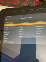
Not 100% sure but think the main truing/tuning item is "Drag Coeff" under the Bullet section in the track. Default is 0.500, try adjusting it up or down; 0.600, 0.400 etc.Ok thanks. Is there a bc/mv truing function that I'm not seeing? Right now I'm just comparing outputs with Streloc Pro that has been trued & gives very accurate results. Genesis is off a bit.
Thanks.
Can you share the data used for the comparison?Ok thanks. Is there a bc/mv truing function that I'm not seeing? Right now I'm just comparing outputs with Streloc Pro that has been trued & gives very accurate results. Genesis is off a bit.
Thanks.
This is an article about Trasol but it has a pretty good explanation in the last 1/4 about just what Drag Coefficient does and it's pretty neat.I was hoping that this app would have a truing function like Streloc Pro. But not that big a deal. I'll fiddle with the DC & see what I can get.
Thanks.
Lowlight explained far better than I ever could do justice about. but with this engine you don't need to true or tweak data as long as the inputs are correct. Making adjustment to MV or BC even when they are correct is the common way with Point Mass based calculators, which obvioulsy makes no sense at all thus showing the weakness of those programs. As a long time user of CB (and now Genesis) I can assure you it's the best LR/ELR tool you will ever need.I was hoping that this app would have a truing function like Streloc Pro. But not that big a deal. I'll fiddle with the DC & see what I can get.
Thanks.
I'd be glad to run some numbers if you want to share your load's complete data and actual dope.That may be true. However in my case I've found that even CB & FFS need some tweaking. I've only had it out once so far & with the same inputs as Streloc Pro it didn't match. I've trued Streloc Pro & it has been spot on well into elr ranges. That's about all I do anymore. I'll have to fiddle with it a bit more. I'm running a 230 ATIP in a lhgt 9.5-8.75 tw barrel @ 2909 fps. Hornady doesn't provide a BC for my twist so...
I'll continue to work with it.